Kızılırmak geodata
Kızılırmak (Çankırı) is a seat of a second-order administrative division; located in Turkey in Europe/Istanbul (GMT+3) time zone. With population of 3,260 people, there are 842 cities with bigger population in this country. Compared to other cities in Turkey, 75.2% of cities are located further ↓South; 58.5% of cities are located further →East and 56.9% of cities have higher elevation than Kızılırmak. Note1


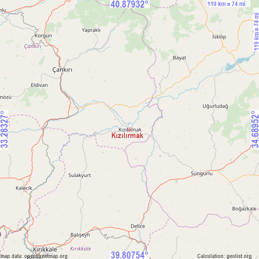
Kızılırmak GPS coordinates[2]
40° 20' 44.016" North, 33° 59' 11.004" East
| Map corner | latitude | longitude |
|---|---|---|
| Upper-left | 40.87932°, | 33.28327° |
| Center: | 40.34556°, | 33.98639° |
| Lower-right: | 39.80754°, | 34.68952° |
| Map W x H: | 119.2×119.2 km | = 74.1×74.1mi |
| max Lat: | 42.02683° ⇑24.8% North |
| Kızılırmak: | 40.34556° |
| min Lat: | ⇓75.2% South 35.9025° |
| min Long | Kızılırmak | max Long |
| 25.90902° | 33.98639° | 44.60099° |
| W 41.5%⇐ | ⇒58.5% E |
Elevation
Elevation of Kızılırmak is 556 m = 1824 ft, and this is 161.4 m = 530 ft below average elevation for this country.
| Max E: |
2682 m = 8799 ft | 56.9% |
| Avg. | 717.4 m = 2354 ft | |
| Kızılırmak | 556 m = 1824 ft | |
Min E: |
0 m = 0 ft | 43.1% |
See also: Turkey elevation on elevation.city.
Geographical zone
Kızılırmak is located in North temperate zone (between Tropic of Cancer and the Arctic Circle). Distance of this Northern Tropic circle is 1880.1 km =1168.2 mi to South.| Distance of | km | miles | from Kızılırmak |
|---|---|---|---|
| North Pole | 5521.1 | 3430.7 | to North |
| Arctic Circle | 2915.2 | 1811.4 | to North |
| Tropic Cancer | 1880.1 | 1168.2 | to South |
| Equator | 4486 | 2787.5 | to South |


Nearby cities:
15 places around Kızılırmak: (largest is in red/bold)
• Balışeyh
52.9 km =32.9 mi,  204°
204°
• Bayat
40.7 km =25.3 mi,  34°
34°
• Delice
43.7 km =27.2 mi,  175°
175°
• Eldivan
46 km =28.6 mi,  296°
296°
• Hasayaz
57 km =35.4 mi,  258°
258°
• Kalecik
56.3 km =35 mi,  240°
240°
• Khanjarah
42.3 km =26.3 mi,  312°
312°
• Korgun
58.6 km =36.4 mi,  317°
317°
• Salmanlı
54.3 km =33.7 mi,  155°
155°
• Sulakyurt
31.1 km =19.3 mi,  227°
227°
• Sungurlu
38.4 km =23.9 mi,  121°
121°
• Uğurludağ
41 km =25.5 mi,  74°
74°
• Yapraklı
49.1 km =30.5 mi,  339°
339°
• Çandır
45 km =28 mi, 257°
• İkizören
39.1 km =24.3 mi,  347°
347°
Sources, notices
• [Note1] Compared only with cities in Turkey existing in our database
• [Src1] Map data: © OpenStreetMap contributors (CC-BY-SA)
• [Src2] Other city data from geonames.org with taken over terms of usage.
• [Src3] Geographical zone / Annual Mean Temperature by Robert A. Rohde @ Wikipedia
