Samsun geodata
Samsun is a seat of a first-order administrative division; located in Turkey in Europe/Istanbul (GMT+3) time zone. With population of 394,050 people, there are 25 cities with bigger population in this country. Compared to other cities in Turkey, 95.5% of cities are located further ↓South; 53.7% of cities are located further ←West and 86.2% of cities have higher elevation than Samsun. Note1


Samsun GPS coordinates[2]
41° 16' 47.136" North, 36° 20' 9.96" East
| Map corner | latitude | longitude |
|---|---|---|
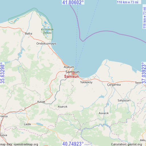
| Upper-left | 41.80602°, | 35.63298° |
| Center: | 41.27976°, | 36.3361° |
| Lower-right: | 40.74923°, | 37.03923° |
| Map W x H: | 117.5×117.5 km | = 73×73mi |
| max Lat: | 42.02683° ⇑4.5% North |
| Samsun: | 41.27976° |
| min Lat: | ⇓95.5% South 35.9025° |
| min Long | Samsun | max Long |
| 25.90902° | 36.3361° | 44.60099° |
| W 53.7%⇐ | ⇒46.3% E |
Elevation
Elevation of Samsun is 64 m = 210 ft, and this is 653.4 m = 2144 ft below average elevation for this country.
| Max E: |
2682 m = 8799 ft | 86.2% |
| Avg. | 717.4 m = 2354 ft | |
| Samsun | 64 m = 210 ft | |
Min E: |
0 m = 0 ft | 13.8% |
See also: Samsun elevation on elevation.city.
Geographical zone
Samsun is located in North temperate zone (between Tropic of Cancer and the Arctic Circle). Distance of this Northern Tropic circle is 1984 km =1232.8 mi to South.| Distance of | km | miles | from Samsun |
|---|---|---|---|
| North Pole | 5417.2 | 3366.1 | to North |
| Arctic Circle | 2811.3 | 1746.9 | to North |
| Tropic Cancer | 1984 | 1232.8 | to South |
| Equator | 4589.9 | 2852 | to South |


Nearby cities:
15 places around Samsun: (largest is in red/bold)
• Asarcık
28.4 km =17.6 mi,  197°
197°
• Ayvacık
40.5 km =25.2 mi,  142°
142°
• Bafra
48 km =29.8 mi,  311°
311°
• Boğazkaya
43.5 km =27 mi,  295°
295°
• Dikbıyık
24.2 km =15 mi,  105°
105°
• Kavak
33.2 km =20.6 mi,  227°
227°
• Kolay
47.2 km =29.3 mi,  289°
289°
• Ondokuzmayıs
33.2 km =20.6 mi,  317°
317°
• Salıpazarı
46.7 km =29 mi,  117°
117°
• Taflan
22.5 km =14 mi, 309°
• Tekkeköy
12.8 km =8 mi,  126°
126°
• Çarşamba
33.5 km =20.8 mi, 105°
• Çayırkent
12.1 km =7.5 mi,  182°
182°
• İlkadım
3.9 km =2.4 mi,  282°
282°
• Şeyhli
45.9 km =28.5 mi,  209°
209°
Sources, notices
• [Note1] Compared only with cities in Turkey existing in our database
• [Src1] Map data: © OpenStreetMap contributors (CC-BY-SA)
• [Src2] Other city data from geonames.org with taken over terms of usage.
• [Src3] Geographical zone / Annual Mean Temperature by Robert A. Rohde @ Wikipedia
