Ondokuzmayıs geodata
Ondokuzmayıs (Samsun) is a seat of a second-order administrative division; located in Turkey in Europe/Istanbul (GMT+3) time zone. In our database, there are 1323 cities with bigger population. Compared to other cities in Turkey, 97.5% of cities are located further ↓South; 50.5% of cities are located further ←West and 97.5% of cities have higher elevation than Ondokuzmayıs. Note1


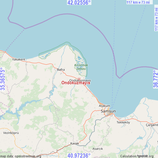
Ondokuzmayıs GPS coordinates[2]
41° 30' 3.96" North, 36° 4' 7.932" East
| Map corner | latitude | longitude |
|---|---|---|
| Upper-left | 42.02556°, | 35.36575° |
| Center: | 41.5011°, | 36.06887° |
| Lower-right: | 40.97236°, | 36.772° |
| Map W x H: | 117.1×117.1 km | = 72.8×72.8mi |
| max Lat: | 42.02683° ⇑2.5% North |
| Ondokuzmayıs: | 41.5011° |
| min Lat: | ⇓97.5% South 35.9025° |
| min Long | Ondokuzmayıs | max Long |
| 25.90902° | 36.06887° | 44.60099° |
| W 50.5%⇐ | ⇒49.5% E |
Elevation
Elevation of Ondokuzmayıs is 11 m = 36 ft, and this is 706.4 m = 2318 ft below average elevation for this country.
| Max E: |
2682 m = 8799 ft | 97.5% |
| Avg. | 717.4 m = 2354 ft | |
| Ondokuzmayıs | 11 m = 36 ft | |
Min E: |
0 m = 0 ft | 2.5% |
See also: Turkey elevation on elevation.city.
Geographical zone
Ondokuzmayıs is located in North temperate zone (between Tropic of Cancer and the Arctic Circle). Distance of this Northern Tropic circle is 2008.6 km =1248.1 mi to South.| Distance of | km | miles | from Ondokuzmayıs |
|---|---|---|---|
| North Pole | 5392.6 | 3350.8 | to North |
| Arctic Circle | 2786.7 | 1731.6 | to North |
| Tropic Cancer | 2008.6 | 1248.1 | to South |
| Equator | 4614.5 | 2867.3 | to South |


Nearby cities:
15 places around Ondokuzmayıs: (largest is in red/bold)
• Alaçam
40.9 km =25.4 mi,  286°
286°
• Asarcık
53.6 km =33.3 mi,  164°
164°
• Bafra
15.4 km =9.6 mi,  298°
298°
• Boğazkaya
17.8 km =11.1 mi,  251°
251°
• Dikbıyık
55.2 km =34.3 mi,  124°
124°
• Kavak
47.1 km =29.3 mi,  182°
182°
• Kolay
24.1 km =15 mi, 247°
• Samsun
33.2 km =20.6 mi,  137°
137°
• Taflan
11.4 km =7.1 mi,  153°
153°
• Tekkeköy
45.8 km =28.5 mi,  134°
134°
• Yakakent
47.2 km =29.3 mi, 288°
• Çakıralan
45.1 km =28 mi,  214°
214°
• Çarşamba
64 km =39.8 mi, 121°
• Çayırkent
42.6 km =26.5 mi, 149°
• İlkadım
30.1 km =18.7 mi, 142°
Sources, notices
• [Note1] Compared only with cities in Turkey existing in our database
• [Src1] Map data: © OpenStreetMap contributors (CC-BY-SA)
• [Src2] Other city data from geonames.org with taken over terms of usage.
• [Src3] Geographical zone / Annual Mean Temperature by Robert A. Rohde @ Wikipedia
