Kolay geodata
Kolay (Samsun) is a seat of a third-order administrative division; located in Turkey in Europe/Istanbul (GMT+3) time zone. In our database, there are 1323 cities with bigger population. Compared to other cities in Turkey, 96.6% of cities are located further ↓South; 50.7% of cities are located further →East and 84.9% of cities have higher elevation than Kolay. Note1


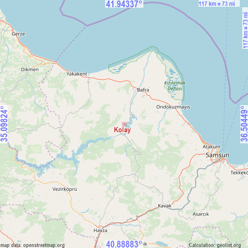
Kolay GPS coordinates[2]
41° 25' 5.664" North, 35° 48' 4.896" East
| Map corner | latitude | longitude |
|---|---|---|
| Upper-left | 41.94337°, | 35.09824° |
| Center: | 41.41824°, | 35.80136° |
| Lower-right: | 40.88883°, | 36.50449° |
| Map W x H: | 117.3×117.3 km | = 72.9×72.9mi |
| max Lat: | 42.02683° ⇑3.4% North |
| Kolay: | 41.41824° |
| min Lat: | ⇓96.6% South 35.9025° |
| min Long | Kolay | max Long |
| 25.90902° | 35.80136° | 44.60099° |
| W 49.3%⇐ | ⇒50.7% E |
Elevation
Elevation of Kolay is 72 m = 236 ft, and this is 645.4 m = 2117 ft below average elevation for this country.
| Max E: |
2682 m = 8799 ft | 84.9% |
| Avg. | 717.4 m = 2354 ft | |
| Kolay | 72 m = 236 ft | |
Min E: |
0 m = 0 ft | 15.1% |
See also: Turkey elevation on elevation.city.
Geographical zone
Kolay is located in North temperate zone (between Tropic of Cancer and the Arctic Circle). Distance of this Northern Tropic circle is 1999.4 km =1242.4 mi to South.| Distance of | km | miles | from Kolay |
|---|---|---|---|
| North Pole | 5401.8 | 3356.5 | to North |
| Arctic Circle | 2795.9 | 1737.3 | to North |
| Tropic Cancer | 1999.4 | 1242.4 | to South |
| Equator | 4605.3 | 2861.6 | to South |


Nearby cities:
15 places around Kolay: (largest is in red/bold)
• Alaçam
26.8 km =16.7 mi,  320°
320°
• Bafra
18.8 km =11.7 mi,  27°
27°
• Boğazkaya
6.5 km =4 mi,  57°
57°
• Dikmen
51.4 km =31.9 mi,  300°
300°
• Havza
51.1 km =31.8 mi,  193°
193°
• Kavak
42.8 km =26.6 mi,  151°
151°
• Köprübaşı
47.6 km =29.6 mi,  209°
209°
• Ondokuzmayıs
24.1 km =15 mi,  67°
67°
• Samsun
47.2 km =29.3 mi,  109°
109°
• Taflan
27.3 km =17 mi,  92°
92°
• Vezirköprü
42.1 km =26.2 mi,  223°
223°
• Yakakent
32.9 km =20.4 mi, 316°
• Çakıralan
28 km =17.4 mi, 187°
• Çerçiler
47.2 km =29.3 mi,  266°
266°
• İlkadım
43.3 km =26.9 mi, 109°
Sources, notices
• [Note1] Compared only with cities in Turkey existing in our database
• [Src1] Map data: © OpenStreetMap contributors (CC-BY-SA)
• [Src2] Other city data from geonames.org with taken over terms of usage.
• [Src3] Geographical zone / Annual Mean Temperature by Robert A. Rohde @ Wikipedia
