Asarcık geodata
Asarcık (Samsun) is a seat of a second-order administrative division; located in Turkey in Europe/Istanbul (GMT+3) time zone. With population of 2,154 people, there are 930 cities with bigger population in this country. Compared to other cities in Turkey, 90.5% of cities are located further ↓South; 52.8% of cities are located further ←West and 54.7% of cities have lower elevation than Asarcık. Note1


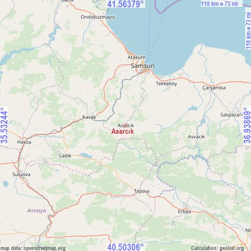
Asarcık GPS coordinates[2]
41° 2' 8.016" North, 36° 14' 8.016" East
| Map corner | latitude | longitude |
|---|---|---|
| Upper-left | 41.56379°, | 35.53244° |
| Center: | 41.03556°, | 36.23556° |
| Lower-right: | 40.50306°, | 36.93869° |
| Map W x H: | 117.9×117.9 km | = 73.3×73.3mi |
| max Lat: | 42.02683° ⇑9.5% North |
| Asarcık: | 41.03556° |
| min Lat: | ⇓90.5% South 35.9025° |
| min Long | Asarcık | max Long |
| 25.90902° | 36.23556° | 44.60099° |
| W 52.8%⇐ | ⇒47.2% E |
Elevation
Elevation of Asarcık is 787 m = 2582 ft, and this is 69.6 m = 228 ft above average elevation for this country.
| Max E: |
2682 m = 8799 ft | 45.3% |
| Asarcık | 787 m 2582 ft | |
| Avg. | 717.4 m = 2354 ft | |
Min E: |
0 m = 0 ft | 54.7% |
See also: Turkey elevation on elevation.city.
Geographical zone
Asarcık is located in North temperate zone (between Tropic of Cancer and the Arctic Circle). Distance of this Northern Tropic circle is 1956.8 km =1215.9 mi to South.| Distance of | km | miles | from Asarcık |
|---|---|---|---|
| North Pole | 5444.3 | 3382.9 | to North |
| Arctic Circle | 2838.4 | 1763.7 | to North |
| Tropic Cancer | 1956.8 | 1215.9 | to South |
| Equator | 4562.7 | 2835.1 | to South |


Nearby cities:
15 places around Asarcık: (largest is in red/bold)
• Akdağ
42 km =26.1 mi,  211°
211°
• Ayvacık
33.6 km =20.9 mi,  98°
98°
• Destek
21.5 km =13.4 mi,  191°
191°
• Dikbıyık
37.9 km =23.5 mi,  57°
57°
• Kavak
16.9 km =10.5 mi,  286°
286°
• Ladik
32 km =19.9 mi,  244°
244°
• Samsun
28.4 km =17.6 mi,  17°
17°
• Taflan
42.5 km =26.4 mi,  347°
347°
• Taşova
31.5 km =19.6 mi,  166°
166°
• Tekke
35.8 km =22.2 mi, 185°
• Tekkeköy
27.1 km =16.8 mi,  43°
43°
• Çakıralan
42.5 km =26.4 mi, 290°
• Çayırkent
17 km =10.6 mi,  27°
27°
• İlkadım
28.4 km =17.6 mi,  9°
9°
• Şeyhli
19.2 km =11.9 mi,  228°
228°
Sources, notices
• [Note1] Compared only with cities in Turkey existing in our database
• [Src1] Map data: © OpenStreetMap contributors (CC-BY-SA)
• [Src2] Other city data from geonames.org with taken over terms of usage.
• [Src3] Geographical zone / Annual Mean Temperature by Robert A. Rohde @ Wikipedia
