Şeyhli geodata
Şeyhli (Samsun) is a seat of a third-order administrative division; located in Turkey in Europe/Istanbul (GMT+3) time zone. In our database, there are 1323 cities with bigger population. Compared to other cities in Turkey, 86.8% of cities are located further ↓South; 50.5% of cities are located further ←West and 64.1% of cities have lower elevation than Şeyhli. Note1


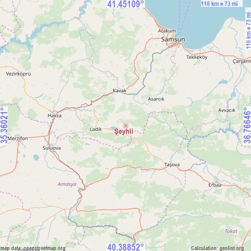
Şeyhli GPS coordinates[2]
40° 55' 18.984" North, 36° 3' 47.988" East
| Map corner | latitude | longitude |
|---|---|---|
| Upper-left | 41.45109°, | 35.36021° |
| Center: | 40.92194°, | 36.06333° |
| Lower-right: | 40.38852°, | 36.76646° |
| Map W x H: | 118.1×118.1 km | = 73.4×73.4mi |
| max Lat: | 42.02683° ⇑13.2% North |
| Şeyhli: | 40.92194° |
| min Lat: | ⇓86.8% South 35.9025° |
| min Long | Şeyhli | max Long |
| 25.90902° | 36.06333° | 44.60099° |
| W 50.5%⇐ | ⇒49.5% E |
Elevation
Elevation of Şeyhli is 947 m = 3107 ft, and this is 229.6 m = 753 ft above average elevation for this country.
| Max E: |
2682 m = 8799 ft | 35.9% |
| Şeyhli | 947 m 3107 ft | |
| Avg. | 717.4 m = 2354 ft | |
Min E: |
0 m = 0 ft | 64.1% |
See also: Turkey elevation on elevation.city.
Geographical zone
Şeyhli is located in North temperate zone (between Tropic of Cancer and the Arctic Circle). Distance of this Northern Tropic circle is 1944.2 km =1208.1 mi to South.| Distance of | km | miles | from Şeyhli |
|---|---|---|---|
| North Pole | 5457 | 3390.8 | to North |
| Arctic Circle | 2851.1 | 1771.6 | to North |
| Tropic Cancer | 1944.2 | 1208.1 | to South |
| Equator | 4550.1 | 2827.3 | to South |


Nearby cities:
15 places around Şeyhli: (largest is in red/bold)
• Akdağ
24.4 km =15.2 mi,  197°
197°
• Amasya
35.6 km =22.1 mi,  212°
212°
• Asarcık
19.2 km =11.9 mi,  48°
48°
• Destek
13.1 km =8.1 mi,  129°
129°
• Esençay
38.8 km =24.1 mi,  136°
136°
• Ezinepazarı
39.7 km =24.7 mi,  170°
170°
• Havza
34.1 km =21.2 mi,  279°
279°
• Kavak
17.5 km =10.9 mi,  354°
354°
• Ladik
14.5 km =9 mi,  264°
264°
• Suluova
36.4 km =22.6 mi,  253°
253°
• Taşova
28.3 km =17.6 mi, 129°
• Tekke
25.4 km =15.8 mi,  154°
154°
• Çakıralan
37.4 km =23.2 mi,  317°
317°
• Çayırkent
35.6 km =22.1 mi,  38°
38°
• İlkadım
44.9 km =27.9 mi,  25°
25°
Sources, notices
• [Note1] Compared only with cities in Turkey existing in our database
• [Src1] Map data: © OpenStreetMap contributors (CC-BY-SA)
• [Src2] Other city data from geonames.org with taken over terms of usage.
• [Src3] Geographical zone / Annual Mean Temperature by Robert A. Rohde @ Wikipedia
