Mezraa geodata
Mezraa (Samsun) is a seat of a third-order administrative division; located in Turkey in Europe/Istanbul (GMT+3) time zone. In our database, there are 1323 cities with bigger population. Compared to other cities in Turkey, 94% of cities are located further ↓South; 53.7% of cities are located further →East and 51.6% of cities have lower elevation than Mezraa. Note1


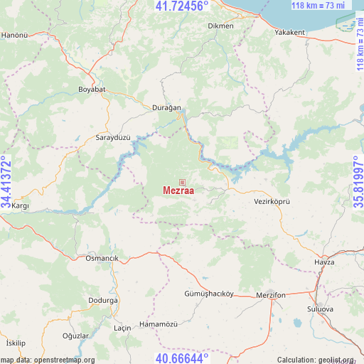
Mezraa GPS coordinates[2]
41° 11' 51.504" North, 35° 7' 0.624" East
| Map corner | latitude | longitude |
|---|---|---|
| Upper-left | 41.72456°, | 34.41372° |
| Center: | 41.19764°, | 35.11684° |
| Lower-right: | 40.66644°, | 35.81997° |
| Map W x H: | 117.7×117.7 km | = 73.1×73.1mi |
| max Lat: | 42.02683° ⇑6% North |
| Mezraa: | 41.19764° |
| min Lat: | ⇓94% South 35.9025° |
| min Long | Mezraa | max Long |
| 25.90902° | 35.11684° | 44.60099° |
| W 46.3%⇐ | ⇒53.7% E |
Elevation
Elevation of Mezraa is 730 m = 2395 ft, and this is 12.6 m = 41 ft above average elevation for this country.
| Max E: |
2682 m = 8799 ft | 48.4% |
| Mezraa | 730 m 2395 ft | |
| Avg. | 717.4 m = 2354 ft | |
Min E: |
0 m = 0 ft | 51.6% |
See also: Turkey elevation on elevation.city.
Geographical zone
Mezraa is located in North temperate zone (between Tropic of Cancer and the Arctic Circle). Distance of this Northern Tropic circle is 1974.8 km =1227.1 mi to South.| Distance of | km | miles | from Mezraa |
|---|---|---|---|
| North Pole | 5426.3 | 3371.7 | to North |
| Arctic Circle | 2820.4 | 1752.5 | to North |
| Tropic Cancer | 1974.8 | 1227.1 | to South |
| Equator | 4580.7 | 2846.3 | to South |


Nearby cities:
15 places around Mezraa: (largest is in red/bold)
• Beşpınar
10.7 km =6.6 mi,  128°
128°
• Boyabat
42 km =26.1 mi,  315°
315°
• Dodurga
46.1 km =28.6 mi,  214°
214°
• Durağan
24.8 km =15.4 mi,  347°
347°
• Gümüş
40 km =24.9 mi,  173°
173°
• Gümüşhacıköy
37 km =23 mi, 167°
• Hamamözü
46.5 km =28.9 mi,  189°
189°
• Kâmil
31.4 km =19.5 mi,  250°
250°
• Köprübaşı
37.4 km =23.2 mi,  116°
116°
• Merzifon
46.3 km =28.8 mi,  141°
141°
• Osmancık
35.8 km =22.2 mi,  226°
226°
• Saraycık
27.5 km =17.1 mi,  180°
180°
• Saraydüzü
26.9 km =16.7 mi,  302°
302°
• Vezirköprü
28.9 km =18 mi,  101°
101°
• Çerçiler
24.1 km =15 mi,  24°
24°
Sources, notices
• [Note1] Compared only with cities in Turkey existing in our database
• [Src1] Map data: © OpenStreetMap contributors (CC-BY-SA)
• [Src2] Other city data from geonames.org with taken over terms of usage.
• [Src3] Geographical zone / Annual Mean Temperature by Robert A. Rohde @ Wikipedia
