Kâmil geodata
Kâmil (Çorum) is a seat of a third-order administrative division; located in Turkey in Europe/Istanbul (GMT+3) time zone. In our database, there are 1323 cities with bigger population. Compared to other cities in Turkey, 92.4% of cities are located further ↓South; 55.4% of cities are located further →East and 64.7% of cities have higher elevation than Kâmil. Note1


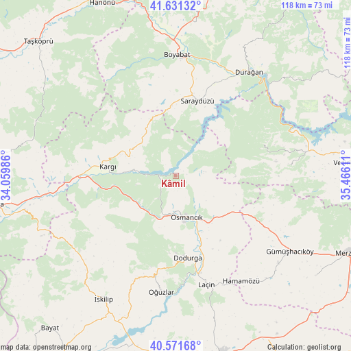
Kâmil GPS coordinates[2]
41° 6' 13.104" North, 34° 45' 46.728" East
| Map corner | latitude | longitude |
|---|---|---|
| Upper-left | 41.63132°, | 34.05986° |
| Center: | 41.10364°, | 34.76298° |
| Lower-right: | 40.57168°, | 35.46611° |
| Map W x H: | 117.8×117.8 km | = 73.2×73.2mi |
| max Lat: | 42.02683° ⇑7.6% North |
| Kâmil: | 41.10364° |
| min Lat: | ⇓92.4% South 35.9025° |
| min Long | Kâmil | max Long |
| 25.90902° | 34.76298° | 44.60099° |
| W 44.6%⇐ | ⇒55.4% E |
Elevation
Elevation of Kâmil is 424 m = 1391 ft, and this is 293.4 m = 963 ft below average elevation for this country.
| Max E: |
2682 m = 8799 ft | 64.7% |
| Avg. | 717.4 m = 2354 ft | |
| Kâmil | 424 m = 1391 ft | |
Min E: |
0 m = 0 ft | 35.3% |
See also: Turkey elevation on elevation.city.
Geographical zone
Kâmil is located in North temperate zone (between Tropic of Cancer and the Arctic Circle). Distance of this Northern Tropic circle is 1964.4 km =1220.6 mi to South.| Distance of | km | miles | from Kâmil |
|---|---|---|---|
| North Pole | 5436.8 | 3378.3 | to North |
| Arctic Circle | 2830.9 | 1759 | to North |
| Tropic Cancer | 1964.4 | 1220.6 | to South |
| Equator | 4570.3 | 2839.9 | to South |


Nearby cities:
15 places around Kâmil: (largest is in red/bold)
• Beşpınar
38.2 km =23.7 mi,  84°
84°
• Boyabat
40.6 km =25.2 mi,  0°
0°
• Dodurga
27.9 km =17.3 mi,  172°
172°
• Durağan
42.4 km =26.3 mi,  35°
35°
• Gümüş
45.1 km =28 mi,  130°
130°
• Gümüşhacıköy
45.8 km =28.5 mi,  124°
124°
• Hacıhamza
26.5 km =16.5 mi,  262°
262°
• Hamamözü
41.8 km =26 mi,  148°
148°
• Kargı
23.3 km =14.5 mi,  278°
278°
• Laçin
37.9 km =23.5 mi,  164°
164°
• Mezraa
31.4 km =19.5 mi,  70°
70°
• Osmancık
14.4 km =8.9 mi, 165°
• Oğuzlar
39.3 km =24.4 mi,  187°
187°
• Saraycık
33.9 km =21.1 mi, 120°
• Saraydüzü
26 km =16.2 mi,  15°
15°
Sources, notices
• [Note1] Compared only with cities in Turkey existing in our database
• [Src1] Map data: © OpenStreetMap contributors (CC-BY-SA)
• [Src2] Other city data from geonames.org with taken over terms of usage.
• [Src3] Geographical zone / Annual Mean Temperature by Robert A. Rohde @ Wikipedia
