Hacıhamza geodata
Hacıhamza (Çorum) is a seat of a third-order administrative division; located in Turkey in Europe/Istanbul (GMT+3) time zone. In our database, there are 1323 cities with bigger population. Compared to other cities in Turkey, 91.7% of cities are located further ↓South; 56.8% of cities are located further →East and 65.8% of cities have higher elevation than Hacıhamza. Note1


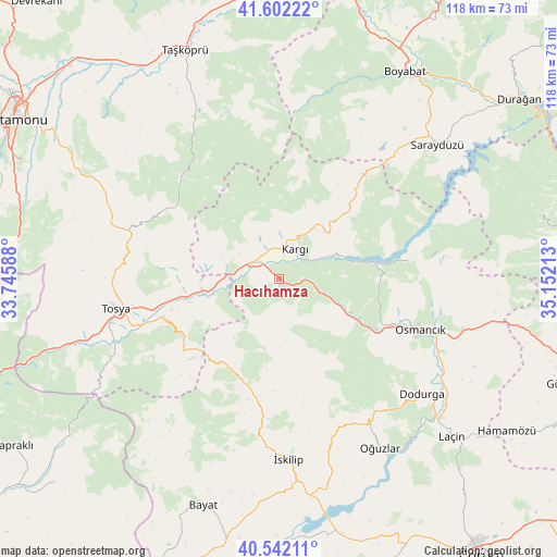
Hacıhamza GPS coordinates[2]
41° 4' 27.48" North, 34° 26' 56.4" East
| Map corner | latitude | longitude |
|---|---|---|
| Upper-left | 41.60222°, | 33.74588° |
| Center: | 41.0743°, | 34.449° |
| Lower-right: | 40.54211°, | 35.15213° |
| Map W x H: | 117.9×117.9 km | = 73.3×73.3mi |
| max Lat: | 42.02683° ⇑8.3% North |
| Hacıhamza: | 41.0743° |
| min Lat: | ⇓91.7% South 35.9025° |
| min Long | Hacıhamza | max Long |
| 25.90902° | 34.449° | 44.60099° |
| W 43.2%⇐ | ⇒56.8% E |
Elevation
Elevation of Hacıhamza is 392 m = 1286 ft, and this is 325.4 m = 1068 ft below average elevation for this country.
| Max E: |
2682 m = 8799 ft | 65.8% |
| Avg. | 717.4 m = 2354 ft | |
| Hacıhamza | 392 m = 1286 ft | |
Min E: |
0 m = 0 ft | 34.2% |
See also: Turkey elevation on elevation.city.
Geographical zone
Hacıhamza is located in North temperate zone (between Tropic of Cancer and the Arctic Circle). Distance of this Northern Tropic circle is 1961.1 km =1218.6 mi to South.| Distance of | km | miles | from Hacıhamza |
|---|---|---|---|
| North Pole | 5440 | 3380.3 | to North |
| Arctic Circle | 2834.1 | 1761 | to North |
| Tropic Cancer | 1961.1 | 1218.6 | to South |
| Equator | 4567 | 2837.8 | to South |


Nearby cities:
15 places around Hacıhamza: (largest is in red/bold)
• Bayat
50.2 km =31.2 mi,  198°
198°
• Boyabat
51.3 km =31.9 mi,  31°
31°
• Dodurga
38.7 km =24 mi,  129°
129°
• Hamamözü
58.2 km =36.2 mi,  123°
123°
• Kargı
7.4 km =4.6 mi, 25°
• Kâmil
26.5 km =16.5 mi,  82°
82°
• Laçin
49.2 km =30.6 mi, 132°
• Mezraa
57.6 km =35.8 mi, 76°
• Osmancık
31.7 km =19.7 mi,  109°
109°
• Oğuzlar
41.6 km =25.8 mi,  149°
149°
• Saraycık
57.3 km =35.6 mi,  103°
103°
• Saraydüzü
43.7 km =27.2 mi,  49°
49°
• Taşköprü
52.2 km =32.4 mi,  337°
337°
• Tosya
34.9 km =21.7 mi,  259°
259°
• İskilip
37.8 km =23.5 mi,  176°
176°
Sources, notices
• [Note1] Compared only with cities in Turkey existing in our database
• [Src1] Map data: © OpenStreetMap contributors (CC-BY-SA)
• [Src2] Other city data from geonames.org with taken over terms of usage.
• [Src3] Geographical zone / Annual Mean Temperature by Robert A. Rohde @ Wikipedia
