Kargı geodata
Kargı (Çorum) is a seat of a second-order administrative division; located in Turkey in Europe/Istanbul (GMT+3) time zone. In our database, there are 1323 cities with bigger population. Compared to other cities in Turkey, 92.9% of cities are located further ↓South; 56.5% of cities are located further →East and 66% of cities have higher elevation than Kargı. Note1


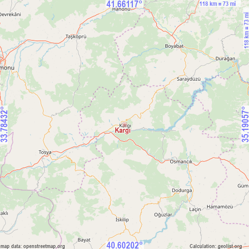
Kargı GPS coordinates[2]
41° 8' 1.428" North, 34° 29' 14.784" East
| Map corner | latitude | longitude |
|---|---|---|
| Upper-left | 41.66117°, | 33.78432° |
| Center: | 41.13373°, | 34.48744° |
| Lower-right: | 40.60202°, | 35.19057° |
| Map W x H: | 117.8×117.8 km | = 73.2×73.2mi |
| max Lat: | 42.02683° ⇑7.1% North |
| Kargı: | 41.13373° |
| min Lat: | ⇓92.9% South 35.9025° |
| min Long | Kargı | max Long |
| 25.90902° | 34.48744° | 44.60099° |
| W 43.5%⇐ | ⇒56.5% E |
Elevation
Elevation of Kargı is 390 m = 1280 ft, and this is 327.4 m = 1074 ft below average elevation for this country.
| Max E: |
2682 m = 8799 ft | 66% |
| Avg. | 717.4 m = 2354 ft | |
| Kargı | 390 m = 1280 ft | |
Min E: |
0 m = 0 ft | 34% |
See also: Turkey elevation on elevation.city.
Geographical zone
Kargı is located in North temperate zone (between Tropic of Cancer and the Arctic Circle). Distance of this Northern Tropic circle is 1967.7 km =1222.7 mi to South.| Distance of | km | miles | from Kargı |
|---|---|---|---|
| North Pole | 5433.4 | 3376.2 | to North |
| Arctic Circle | 2827.5 | 1756.9 | to North |
| Tropic Cancer | 1967.7 | 1222.7 | to South |
| Equator | 4573.6 | 2841.9 | to South |


Nearby cities:
15 places around Kargı: (largest is in red/bold)
• Boyabat
44 km =27.3 mi,  32°
32°
• Dodurga
41 km =25.5 mi,  139°
139°
• Durağan
56.8 km =35.3 mi,  56°
56°
• Hacıhamza
7.4 km =4.6 mi,  205°
205°
• Hanönü
54.9 km =34.1 mi,  358°
358°
• Kâmil
23.3 km =14.5 mi,  98°
98°
• Laçin
51.8 km =32.2 mi, 140°
• Mezraa
53.2 km =33.1 mi,  82°
82°
• Osmancık
31.7 km =19.7 mi,  123°
123°
• Oğuzlar
46 km =28.6 mi,  156°
156°
• Saraycık
56.2 km =34.9 mi,  111°
111°
• Saraydüzü
37.1 km =23.1 mi,  54°
54°
• Taşköprü
47.6 km =29.6 mi,  331°
331°
• Tosya
39.7 km =24.7 mi,  250°
250°
• İskilip
44.3 km =27.5 mi,  181°
181°
Sources, notices
• [Note1] Compared only with cities in Turkey existing in our database
• [Src1] Map data: © OpenStreetMap contributors (CC-BY-SA)
• [Src2] Other city data from geonames.org with taken over terms of usage.
• [Src3] Geographical zone / Annual Mean Temperature by Robert A. Rohde @ Wikipedia
