Olur geodata
Olur (Erzurum) is a seat of a second-order administrative division; located in Turkey in Europe/Istanbul (GMT+3) time zone. With population of 3,546 people, there are 821 cities with bigger population in this country. Compared to other cities in Turkey, 84.2% of cities are located further ↓South; 91.5% of cities are located further ←West and 91.2% of cities have lower elevation than Olur. Note1


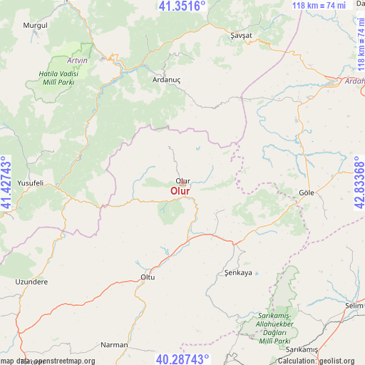
Olur GPS coordinates[2]
40° 49' 17.94" North, 42° 7' 49.98" East
| Map corner | latitude | longitude |
|---|---|---|
| Upper-left | 41.3516°, | 41.42743° |
| Center: | 40.82165°, | 42.13055° |
| Lower-right: | 40.28743°, | 42.83368° |
| Map W x H: | 118.3×118.3 km | = 73.5×73.5mi |
| max Lat: | 42.02683° ⇑15.8% North |
| Olur: | 40.82165° |
| min Lat: | ⇓84.2% South 35.9025° |
| min Long | Olur | max Long |
| 25.90902° | 42.13055° | 44.60099° |
| W 91.5%⇐ | ⇒8.5% E |
Elevation
Elevation of Olur is 1514 m = 4967 ft, and this is 796.6 m = 2614 ft above average elevation for this country.
| Max E: |
2682 m = 8799 ft | 8.8% |
| Olur | 1514 m 4967 ft | |
| Avg. | 717.4 m = 2354 ft | |
Min E: |
0 m = 0 ft | 91.2% |
See also: Turkey elevation on elevation.city.
Geographical zone
Olur is located in North temperate zone (between Tropic of Cancer and the Arctic Circle). Distance of this Northern Tropic circle is 1933 km =1201.1 mi to South.| Distance of | km | miles | from Olur |
|---|---|---|---|
| North Pole | 5468.1 | 3397.7 | to North |
| Arctic Circle | 2862.2 | 1778.5 | to North |
| Tropic Cancer | 1933 | 1201.1 | to South |
| Equator | 4538.9 | 2820.3 | to South |


Nearby cities:
15 places around Olur: (largest is in red/bold)
• Akşar
26.2 km =16.3 mi,  137°
137°
• Ardanuç
34.5 km =21.4 mi,  350°
350°
• Artvin
47.7 km =29.6 mi,  327°
327°
• Aşağı Irmaklar
40.3 km =25 mi,  5°
5°
• Demirkent
34.3 km =21.3 mi,  280°
280°
• Gaziler
48.1 km =29.9 mi,  157°
157°
• Göle
40.2 km =25 mi,  95°
95°
• Kömürlü
16.4 km =10.2 mi,  125°
125°
• Oltu
33.6 km =20.9 mi,  201°
201°
• Ortaköy
49.3 km =30.6 mi, 345°
• Seyitler
48.3 km =30 mi, 329°
• Yalnızçam
41.2 km =25.6 mi,  49°
49°
• Zeytinlik
39.4 km =24.5 mi,  324°
324°
• Öğdem
42.9 km =26.7 mi, 284°
• Şenkaya
34.5 km =21.4 mi,  148°
148°
Sources, notices
• [Note1] Compared only with cities in Turkey existing in our database
• [Src1] Map data: © OpenStreetMap contributors (CC-BY-SA)
• [Src2] Other city data from geonames.org with taken over terms of usage.
• [Src3] Geographical zone / Annual Mean Temperature by Robert A. Rohde @ Wikipedia
