Kömürlü geodata
Kömürlü (Erzurum) is a seat of a third-order administrative division; located in Turkey in Europe/Istanbul (GMT+3) time zone. In our database, there are 1323 cities with bigger population. Compared to other cities in Turkey, 81.9% of cities are located further ↓South; 92.6% of cities are located further ←West and 88.2% of cities have lower elevation than Kömürlü. Note1


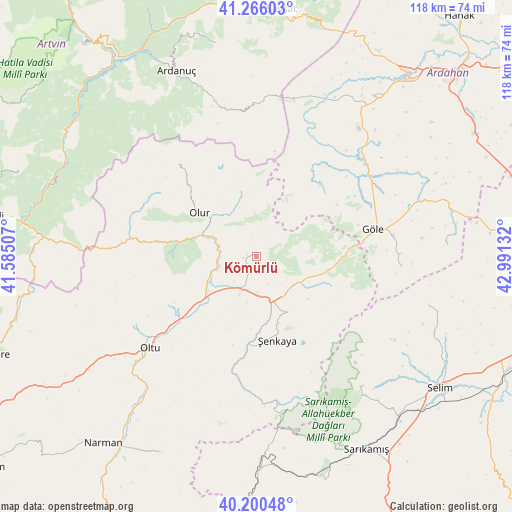
Kömürlü GPS coordinates[2]
40° 44' 7.404" North, 42° 17' 17.484" East
| Map corner | latitude | longitude |
|---|---|---|
| Upper-left | 41.26603°, | 41.58507° |
| Center: | 40.73539°, | 42.28819° |
| Lower-right: | 40.20048°, | 42.99132° |
| Map W x H: | 118.5×118.5 km | = 73.6×73.6mi |
| max Lat: | 42.02683° ⇑18.1% North |
| Kömürlü: | 40.73539° |
| min Lat: | ⇓81.9% South 35.9025° |
| min Long | Kömürlü | max Long |
| 25.90902° | 42.28819° | 44.60099° |
| W 92.6%⇐ | ⇒7.4% E |
Elevation
Elevation of Kömürlü is 1401 m = 4596 ft, and this is 683.6 m = 2243 ft above average elevation for this country.
| Max E: |
2682 m = 8799 ft | 11.8% |
| Kömürlü | 1401 m 4596 ft | |
| Avg. | 717.4 m = 2354 ft | |
Min E: |
0 m = 0 ft | 88.2% |
See also: Turkey elevation on elevation.city.
Geographical zone
Kömürlü is located in North temperate zone (between Tropic of Cancer and the Arctic Circle). Distance of this Northern Tropic circle is 1923.4 km =1195.1 mi to South.| Distance of | km | miles | from Kömürlü |
|---|---|---|---|
| North Pole | 5477.7 | 3403.7 | to North |
| Arctic Circle | 2871.8 | 1784.5 | to North |
| Tropic Cancer | 1923.4 | 1195.1 | to South |
| Equator | 4529.4 | 2814.4 | to South |


Nearby cities:
15 places around Kömürlü: (largest is in red/bold)
• Akşar
10.8 km =6.7 mi,  156°
156°
• Ardahan
54.2 km =33.7 mi,  39°
39°
• Ardanuç
47.5 km =29.5 mi,  336°
336°
• Aşağı Irmaklar
50.7 km =31.5 mi,  349°
349°
• Demirkent
49.7 km =30.9 mi,  288°
288°
• Gaziler
35.3 km =21.9 mi,  171°
171°
• Göle
27.4 km =17 mi,  77°
77°
• Karaurgan
55.1 km =34.2 mi,  181°
181°
• Kışlaköy
51 km =31.7 mi,  206°
206°
• Oltu
33.5 km =20.8 mi,  229°
229°
• Olur
16.4 km =10.2 mi,  305°
305°
• Sarıkamış
51.9 km =32.2 mi,  150°
150°
• Selim
51.9 km =32.2 mi,  126°
126°
• Yalnızçam
40.7 km =25.3 mi,  26°
26°
• Şenkaya
20.4 km =12.7 mi, 166°
Sources, notices
• [Note1] Compared only with cities in Turkey existing in our database
• [Src1] Map data: © OpenStreetMap contributors (CC-BY-SA)
• [Src2] Other city data from geonames.org with taken over terms of usage.
• [Src3] Geographical zone / Annual Mean Temperature by Robert A. Rohde @ Wikipedia
