Şenkaya geodata
Şenkaya (Erzurum) is a seat of a second-order administrative division; located in Turkey in Europe/Istanbul (GMT+3) time zone. With population of 3,995 people, there are 780 cities with bigger population in this country. Compared to other cities in Turkey, 78.5% of cities are located further ↓South; 93.2% of cities are located further ←West and 97.1% of cities have lower elevation than Şenkaya. Note1


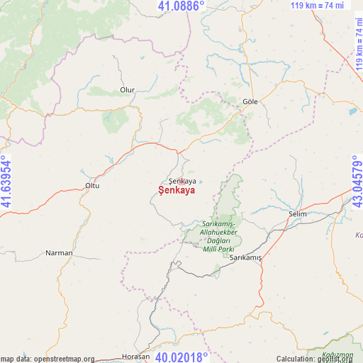
Şenkaya GPS coordinates[2]
40° 33' 23.472" North, 42° 20' 33.576" East
| Map corner | latitude | longitude |
|---|---|---|
| Upper-left | 41.0886°, | 41.63954° |
| Center: | 40.55652°, | 42.34266° |
| Lower-right: | 40.02018°, | 43.04579° |
| Map W x H: | 118.8×118.8 km | = 73.8×73.8mi |
| max Lat: | 42.02683° ⇑21.5% North |
| Şenkaya: | 40.55652° |
| min Lat: | ⇓78.5% South 35.9025° |
| min Long | Şenkaya | max Long |
| 25.90902° | 42.34266° | 44.60099° |
| W 93.2%⇐ | ⇒6.8% E |
Elevation
Elevation of Şenkaya is 1791 m = 5876 ft, and this is 1073.6 m = 3522 ft above average elevation for this country.
| Max E: |
2682 m = 8799 ft | 2.9% |
| Şenkaya | 1791 m 5876 ft | |
| Avg. | 717.4 m = 2354 ft | |
Min E: |
0 m = 0 ft | 97.1% |
See also: Turkey elevation on elevation.city.
Geographical zone
Şenkaya is located in North temperate zone (between Tropic of Cancer and the Arctic Circle). Distance of this Northern Tropic circle is 1903.5 km =1182.8 mi to South.| Distance of | km | miles | from Şenkaya |
|---|---|---|---|
| North Pole | 5497.6 | 3416 | to North |
| Arctic Circle | 2891.7 | 1796.8 | to North |
| Tropic Cancer | 1903.5 | 1182.8 | to South |
| Equator | 4509.5 | 2802.1 | to South |


Nearby cities:
15 places around Şenkaya: (largest is in red/bold)
• Akşar
10 km =6.2 mi,  358°
358°
• Gaziler
15 km =9.3 mi,  178°
178°
• Göle
34 km =21.1 mi,  40°
40°
• Horasan
59.5 km =37 mi,  194°
194°
• Karakurt
48.8 km =30.3 mi,  152°
152°
• Karaurgan
35.7 km =22.2 mi, 189°
• Kömürlü
20.4 km =12.7 mi,  346°
346°
• Kışlaköy
37.5 km =23.3 mi,  226°
226°
• Narman
47.1 km =29.3 mi,  239°
239°
• Oltu
30.1 km =18.7 mi,  266°
266°
• Olur
34.5 km =21.4 mi,  328°
328°
• Sarıkamış
32.8 km =20.4 mi,  140°
140°
• Selim
38.8 km =24.1 mi,  106°
106°
• Yalnızçam
58 km =36 mi,  13°
13°
• Çiftlik
54.3 km =33.7 mi, 187°
Sources, notices
• [Note1] Compared only with cities in Turkey existing in our database
• [Src1] Map data: © OpenStreetMap contributors (CC-BY-SA)
• [Src2] Other city data from geonames.org with taken over terms of usage.
• [Src3] Geographical zone / Annual Mean Temperature by Robert A. Rohde @ Wikipedia
