Kemalpaşa geodata
Kemalpaşa (Artvin) is a seat of a second-order administrative division; located in Turkey in Europe/Istanbul (GMT+3) time zone. In our database, there are 1323 cities with bigger population. Compared to other cities in Turkey, 97.4% of cities are located further ↓South; 86.5% of cities are located further ←West and 85.1% of cities have higher elevation than Kemalpaşa. Note1


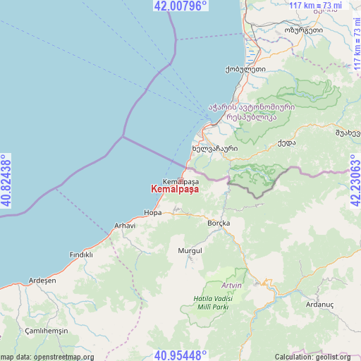
Kemalpaşa GPS coordinates[2]
41° 29' 0.096" North, 41° 31' 39" East
| Map corner | latitude | longitude |
|---|---|---|
| Upper-left | 42.00796°, | 40.82438° |
| Center: | 41.48336°, | 41.5275° |
| Lower-right: | 40.95448°, | 42.23063° |
| Map W x H: | 117.1×117.1 km | = 72.8×72.8mi |
| max Lat: | 42.02683° ⇑2.6% North |
| Kemalpaşa: | 41.48336° |
| min Lat: | ⇓97.4% South 35.9025° |
| min Long | Kemalpaşa | max Long |
| 25.90902° | 41.5275° | 44.60099° |
| W 86.5%⇐ | ⇒13.5% E |
Elevation
Elevation of Kemalpaşa is 71 m = 233 ft, and this is 646.4 m = 2121 ft below average elevation for this country.
| Max E: |
2682 m = 8799 ft | 85.1% |
| Avg. | 717.4 m = 2354 ft | |
| Kemalpaşa | 71 m = 233 ft | |
Min E: |
0 m = 0 ft | 14.9% |
See also: Turkey elevation on elevation.city.
Geographical zone
Kemalpaşa is located in North temperate zone (between Tropic of Cancer and the Arctic Circle). Distance of this Northern Tropic circle is 2006.6 km =1246.8 mi to South.| Distance of | km | miles | from Kemalpaşa |
|---|---|---|---|
| North Pole | 5394.5 | 3352 | to North |
| Arctic Circle | 2788.7 | 1732.8 | to North |
| Tropic Cancer | 2006.6 | 1246.8 | to South |
| Equator | 4612.5 | 2866.1 | to South |


Nearby cities:
15 places around Kemalpaşa: (largest is in red/bold)
• Ardanuç
59.7 km =37.1 mi,  131°
131°
• Ardeşen
55.6 km =34.5 mi,  234°
234°
• Arhavi
23.7 km =14.7 mi, 231°
• Artvin
41.6 km =25.8 mi,  143°
143°
• Borçka
18.1 km =11.2 mi, 140°
• Camili
30.9 km =19.2 mi,  91°
91°
• Fındıklı
40.2 km =25 mi, 233°
• Hopa
13.7 km =8.5 mi,  221°
221°
• Meydancık
59.6 km =37 mi,  97°
97°
• Muratlı
14.9 km =9.3 mi, 93°
• Murgul
22.8 km =14.2 mi,  174°
174°
• Ortacalar
25.9 km =16.1 mi,  208°
208°
• Ortaköy
46 km =28.6 mi,  124°
124°
• Seyitler
41.2 km =25.6 mi, 141°
• Zeytinlik
49.9 km =31 mi,  146°
146°
Sources, notices
• [Note1] Compared only with cities in Turkey existing in our database
• [Src1] Map data: © OpenStreetMap contributors (CC-BY-SA)
• [Src2] Other city data from geonames.org with taken over terms of usage.
• [Src3] Geographical zone / Annual Mean Temperature by Robert A. Rohde @ Wikipedia
