Murgul geodata
Murgul (Artvin) is a seat of a second-order administrative division; located in Turkey in Europe/Istanbul (GMT+3) time zone. With population of 3,549 people, there are 820 cities with bigger population in this country. Compared to other cities in Turkey, 95.4% of cities are located further ↓South; 86.7% of cities are located further ←West and 51.8% of cities have higher elevation than Murgul. Note1


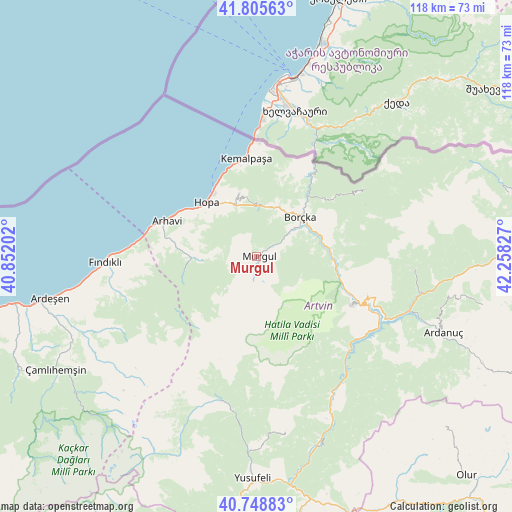
Murgul GPS coordinates[2]
41° 16' 45.732" North, 41° 33' 18.504" East
| Map corner | latitude | longitude |
|---|---|---|
| Upper-left | 41.80563°, | 40.85202° |
| Center: | 41.27937°, | 41.55514° |
| Lower-right: | 40.74883°, | 42.25827° |
| Map W x H: | 117.5×117.5 km | = 73×73mi |
| max Lat: | 42.02683° ⇑4.6% North |
| Murgul: | 41.27937° |
| min Lat: | ⇓95.4% South 35.9025° |
| min Long | Murgul | max Long |
| 25.90902° | 41.55514° | 44.60099° |
| W 86.7%⇐ | ⇒13.3% E |
Elevation
Elevation of Murgul is 661 m = 2169 ft, and this is 56.4 m = 185 ft below average elevation for this country.
| Max E: |
2682 m = 8799 ft | 51.8% |
| Avg. | 717.4 m = 2354 ft | |
| Murgul | 661 m = 2169 ft | |
Min E: |
0 m = 0 ft | 48.2% |
See also: Turkey elevation on elevation.city.
Geographical zone
Murgul is located in North temperate zone (between Tropic of Cancer and the Arctic Circle). Distance of this Northern Tropic circle is 1983.9 km =1232.7 mi to South.| Distance of | km | miles | from Murgul |
|---|---|---|---|
| North Pole | 5417.2 | 3366.1 | to North |
| Arctic Circle | 2811.3 | 1746.9 | to North |
| Tropic Cancer | 1983.9 | 1232.7 | to South |
| Equator | 4589.8 | 2852 | to South |


Nearby cities:
15 places around Murgul: (largest is in red/bold)
• Ardanuç
45.7 km =28.4 mi,  111°
111°
• Arhavi
22.4 km =13.9 mi,  290°
290°
• Artvin
24.8 km =15.4 mi,  115°
115°
• Borçka
12.7 km =7.9 mi,  46°
46°
• Camili
36.2 km =22.5 mi, 52°
• Fındıklı
34.7 km =21.6 mi,  268°
268°
• Hopa
16.7 km =10.4 mi,  317°
317°
• Kemalpaşa
22.8 km =14.2 mi,  354°
354°
• Muratlı
25.1 km =15.6 mi,  30°
30°
• Ortacalar
14.7 km =9.1 mi, 269°
• Ortaköy
36 km =22.4 mi,  95°
95°
• Seyitler
25.4 km =15.8 mi, 111°
• Zeytinlik
31.6 km =19.6 mi,  126°
126°
• Zigopor
37.3 km =23.2 mi,  187°
187°
• Öğdem
40.8 km =25.4 mi,  170°
170°
Sources, notices
• [Note1] Compared only with cities in Turkey existing in our database
• [Src1] Map data: © OpenStreetMap contributors (CC-BY-SA)
• [Src2] Other city data from geonames.org with taken over terms of usage.
• [Src3] Geographical zone / Annual Mean Temperature by Robert A. Rohde @ Wikipedia
