Borçka geodata
Borçka (Artvin) is a seat of a second-order administrative division; located in Turkey in Europe/Istanbul (GMT+3) time zone. With population of 9,942 people, there are 513 cities with bigger population in this country. Compared to other cities in Turkey, 96.2% of cities are located further ↓South; 87.2% of cities are located further ←West and 63.2% of cities have higher elevation than Borçka. Note1


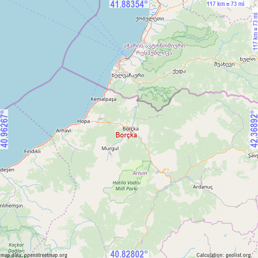
Borçka GPS coordinates[2]
41° 21' 28.512" North, 41° 39' 56.844" East
| Map corner | latitude | longitude |
|---|---|---|
| Upper-left | 41.88354°, | 40.96267° |
| Center: | 41.35792°, | 41.66579° |
| Lower-right: | 40.82802°, | 42.36892° |
| Map W x H: | 117.4×117.4 km | = 72.9×72.9mi |
| max Lat: | 42.02683° ⇑3.8% North |
| Borçka: | 41.35792° |
| min Lat: | ⇓96.2% South 35.9025° |
| min Long | Borçka | max Long |
| 25.90902° | 41.66579° | 44.60099° |
| W 87.2%⇐ | ⇒12.8% E |
Elevation
Elevation of Borçka is 446 m = 1463 ft, and this is 271.4 m = 890 ft below average elevation for this country.
| Max E: |
2682 m = 8799 ft | 63.2% |
| Avg. | 717.4 m = 2354 ft | |
| Borçka | 446 m = 1463 ft | |
Min E: |
0 m = 0 ft | 36.8% |
See also: Turkey elevation on elevation.city.
Geographical zone
Borçka is located in North temperate zone (between Tropic of Cancer and the Arctic Circle). Distance of this Northern Tropic circle is 1992.7 km =1238.2 mi to South.| Distance of | km | miles | from Borçka |
|---|---|---|---|
| North Pole | 5408.5 | 3360.7 | to North |
| Arctic Circle | 2802.6 | 1741.5 | to North |
| Tropic Cancer | 1992.7 | 1238.2 | to South |
| Equator | 4598.6 | 2857.4 | to South |


Nearby cities:
15 places around Borçka: (largest is in red/bold)
• Ardanuç
41.9 km =26 mi,  127°
127°
• Arhavi
30.2 km =18.8 mi,  268°
268°
• Artvin
23.5 km =14.6 mi,  146°
146°
• Aşağı Irmaklar
46.7 km =29 mi,  114°
114°
• Camili
23.6 km =14.7 mi,  55°
55°
• Fındıklı
45 km =28 mi,  257°
257°
• Hopa
20.9 km =13 mi,  279°
279°
• Kemalpaşa
18.1 km =11.2 mi,  320°
320°
• Muratlı
13.4 km =8.3 mi,  14°
14°
• Murgul
12.7 km =7.9 mi,  226°
226°
• Ortacalar
25.5 km =15.8 mi,  249°
249°
• Ortaköy
29.1 km =18.1 mi, 114°
• Seyitler
23.1 km =14.4 mi,  141°
141°
• Zeytinlik
31.9 km =19.8 mi, 149°
• Zigopor
47.8 km =29.7 mi,  197°
197°
Sources, notices
• [Note1] Compared only with cities in Turkey existing in our database
• [Src1] Map data: © OpenStreetMap contributors (CC-BY-SA)
• [Src2] Other city data from geonames.org with taken over terms of usage.
• [Src3] Geographical zone / Annual Mean Temperature by Robert A. Rohde @ Wikipedia
