Arhavi geodata
Arhavi (Artvin) is a seat of a second-order administrative division; located in Turkey in Europe/Istanbul (GMT+3) time zone. With population of 16,217 people, there are 376 cities with bigger population in this country. Compared to other cities in Turkey, 96.1% of cities are located further ↓South; 84.4% of cities are located further ←West and 99.1% of cities have higher elevation than Arhavi. Note1


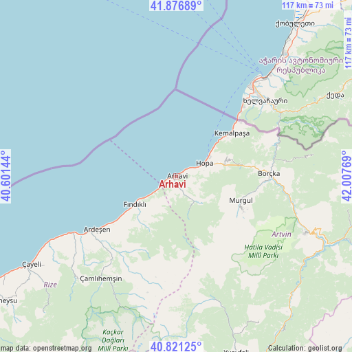
Arhavi GPS coordinates[2]
41° 21' 4.356" North, 41° 18' 16.416" East
| Map corner | latitude | longitude |
|---|---|---|
| Upper-left | 41.87689°, | 40.60144° |
| Center: | 41.35121°, | 41.30456° |
| Lower-right: | 40.82125°, | 42.00769° |
| Map W x H: | 117.4×117.4 km | = 72.9×72.9mi |
| max Lat: | 42.02683° ⇑3.9% North |
| Arhavi: | 41.35121° |
| min Lat: | ⇓96.1% South 35.9025° |
| min Long | Arhavi | max Long |
| 25.90902° | 41.30456° | 44.60099° |
| W 84.4%⇐ | ⇒15.6% E |
Elevation
Elevation of Arhavi is 6 m = 20 ft, and this is 711.4 m = 2334 ft below average elevation for this country.
| Max E: |
2682 m = 8799 ft | 99.1% |
| Avg. | 717.4 m = 2354 ft | |
| Arhavi | 6 m = 20 ft | |
Min E: |
0 m = 0 ft | 0.9% |
See also: Turkey elevation on elevation.city.
Geographical zone
Arhavi is located in North temperate zone (between Tropic of Cancer and the Arctic Circle). Distance of this Northern Tropic circle is 1991.9 km =1237.7 mi to South.| Distance of | km | miles | from Arhavi |
|---|---|---|---|
| North Pole | 5409.2 | 3361.1 | to North |
| Arctic Circle | 2803.4 | 1742 | to North |
| Tropic Cancer | 1991.9 | 1237.7 | to South |
| Equator | 4597.8 | 2856.9 | to South |


Nearby cities:
15 places around Arhavi: (largest is in red/bold)
• Ardeşen
31.9 km =19.8 mi,  236°
236°
• Artvin
47.2 km =29.3 mi,  113°
113°
• Borçka
30.2 km =18.8 mi,  88°
88°
• Fındıklı
16.5 km =10.3 mi, 236°
• Hemşin
47.9 km =29.8 mi,  225°
225°
• Hopa
10.5 km =6.5 mi,  65°
65°
• Kemalpaşa
23.7 km =14.7 mi,  51°
51°
• Muratlı
36.2 km =22.5 mi, 67°
• Murgul
22.4 km =13.9 mi, 110°
• Nurluca
48.5 km =30.1 mi,  223°
223°
• Ortacalar
10.2 km =6.3 mi,  142°
142°
• Pazar
40 km =24.9 mi, 241°
• Seyitler
47.8 km =29.7 mi, 111°
• Zigopor
47.6 km =29.6 mi,  160°
160°
• Çamlıhemşin
42.3 km =26.3 mi, 217°
Sources, notices
• [Note1] Compared only with cities in Turkey existing in our database
• [Src1] Map data: © OpenStreetMap contributors (CC-BY-SA)
• [Src2] Other city data from geonames.org with taken over terms of usage.
• [Src3] Geographical zone / Annual Mean Temperature by Robert A. Rohde @ Wikipedia
