Köse geodata
Köse (Gümüşhane) is a seat of a second-order administrative division; located in Turkey in Europe/Istanbul (GMT+3) time zone. With population of 8,705 people, there are 543 cities with bigger population in this country. Compared to other cities in Turkey, 72.7% of cities are located further ↓South; 71.8% of cities are located further ←West and 93.5% of cities have lower elevation than Köse. Note1


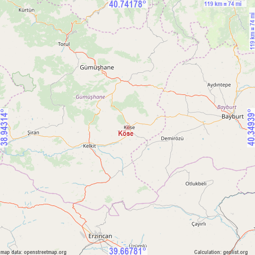
Köse GPS coordinates[2]
40° 12' 24.912" North, 39° 38' 46.536" East
| Map corner | latitude | longitude |
|---|---|---|
| Upper-left | 40.74178°, | 38.94314° |
| Center: | 40.20692°, | 39.64626° |
| Lower-right: | 39.66781°, | 40.34939° |
| Map W x H: | 119.4×119.4 km | = 74.2×74.2mi |
| max Lat: | 42.02683° ⇑27.3% North |
| Köse: | 40.20692° |
| min Lat: | ⇓72.7% South 35.9025° |
| min Long | Köse | max Long |
| 25.90902° | 39.64626° | 44.60099° |
| W 71.8%⇐ | ⇒28.2% E |
Elevation
Elevation of Köse is 1599 m = 5246 ft, and this is 881.6 m = 2892 ft above average elevation for this country.
| Max E: |
2682 m = 8799 ft | 6.5% |
| Köse | 1599 m 5246 ft | |
| Avg. | 717.4 m = 2354 ft | |
Min E: |
0 m = 0 ft | 93.5% |
See also: Turkey elevation on elevation.city.
Geographical zone
Köse is located in North temperate zone (between Tropic of Cancer and the Arctic Circle). Distance of this Northern Tropic circle is 1864.7 km =1158.7 mi to South.| Distance of | km | miles | from Köse |
|---|---|---|---|
| North Pole | 5536.5 | 3440.2 | to North |
| Arctic Circle | 2930.6 | 1821 | to North |
| Tropic Cancer | 1864.7 | 1158.7 | to South |
| Equator | 4470.6 | 2777.9 | to South |


Nearby cities:
15 places around Köse: (largest is in red/bold)
• Aydıntepe
46.4 km =28.8 mi,  65°
65°
• Bayburt
49.3 km =30.6 mi,  83°
83°
• Başköy
40.8 km =25.4 mi,  155°
155°
• Erzincan
53.7 km =33.4 mi,  194°
194°
• Evren
40.2 km =25 mi,  276°
276°
• Gumushkhane
31.8 km =19.8 mi,  332°
332°
• Kale
20.3 km =12.6 mi,  8°
8°
• Kelkit
20.1 km =12.5 mi,  243°
243°
• Otlukbeli
41.2 km =25.6 mi,  129°
129°
• Pulur
21.5 km =13.4 mi,  103°
103°
• Torul
49 km =30.4 mi,  321°
321°
• Yağlıdere
38.8 km =24.1 mi,  345°
345°
• Yağmurdere
44.8 km =27.8 mi,  24°
24°
• Çatalarmut
53 km =32.9 mi,  212°
212°
• Şiran
44.9 km =27.9 mi,  267°
267°
Sources, notices
• [Note1] Compared only with cities in Turkey existing in our database
• [Src1] Map data: © OpenStreetMap contributors (CC-BY-SA)
• [Src2] Other city data from geonames.org with taken over terms of usage.
• [Src3] Geographical zone / Annual Mean Temperature by Robert A. Rohde @ Wikipedia
