Otlukbeli geodata
Otlukbeli (Erzincan) is a seat of a second-order administrative division; located in Turkey in Europe/Istanbul (GMT+3) time zone. With population of 3,669 people, there are 809 cities with bigger population in this country. Compared to other cities in Turkey, 68.6% of cities are located further ↓South; 73.5% of cities are located further ←West and 95.9% of cities have lower elevation than Otlukbeli. Note1


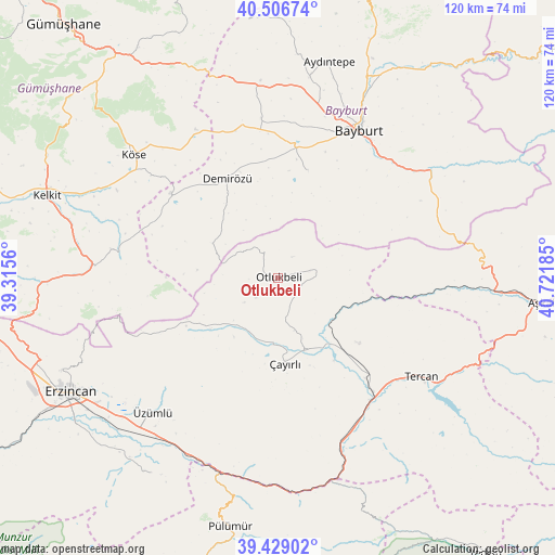
Otlukbeli GPS coordinates[2]
39° 58' 12" North, 40° 1' 7.392" East
| Map corner | latitude | longitude |
|---|---|---|
| Upper-left | 40.50674°, | 39.3156° |
| Center: | 39.97°, | 40.01872° |
| Lower-right: | 39.42902°, | 40.72185° |
| Map W x H: | 119.8×119.8 km | = 74.4×74.4mi |
| max Lat: | 42.02683° ⇑31.4% North |
| Otlukbeli: | 39.97° |
| min Lat: | ⇓68.6% South 35.9025° |
| min Long | Otlukbeli | max Long |
| 25.90902° | 40.01872° | 44.60099° |
| W 73.5%⇐ | ⇒26.5% E |
Elevation
Elevation of Otlukbeli is 1735 m = 5692 ft, and this is 1017.6 m = 3339 ft above average elevation for this country.
| Max E: |
2682 m = 8799 ft | 4.1% |
| Otlukbeli | 1735 m 5692 ft | |
| Avg. | 717.4 m = 2354 ft | |
Min E: |
0 m = 0 ft | 95.9% |
See also: Turkey elevation on elevation.city.
Geographical zone
Otlukbeli is located in North temperate zone (between Tropic of Cancer and the Arctic Circle). Distance of this Northern Tropic circle is 1838.3 km =1142.3 mi to South.| Distance of | km | miles | from Otlukbeli |
|---|---|---|---|
| North Pole | 5562.8 | 3456.6 | to North |
| Arctic Circle | 2956.9 | 1837.3 | to North |
| Tropic Cancer | 1838.3 | 1142.3 | to South |
| Equator | 4444.2 | 2761.5 | to South |


Nearby cities:
15 places around Otlukbeli: (largest is in red/bold)
• Aydıntepe
47.1 km =29.3 mi,  12°
12°
• Bayburt
36.3 km =22.6 mi,  28°
28°
• Başköy
18.6 km =11.6 mi,  234°
234°
• Cimin
39.7 km =24.7 mi,  223°
223°
• Dağyolu
48.9 km =30.4 mi,  191°
191°
• Erzincan
51.9 km =32.2 mi,  240°
240°
• Kelkit
52.7 km =32.7 mi,  289°
289°
• Köse
41.2 km =25.6 mi,  309°
309°
• Maden
40.3 km =25 mi,  54°
54°
• Pulur
23.7 km =14.7 mi,  333°
333°
• Tanyeri
43 km =26.7 mi,  201°
201°
• Tercan
37.4 km =23.2 mi,  124°
124°
• Çayırlı
18.1 km =11.2 mi,  177°
177°
• Çağlayan
51.3 km =31.9 mi,  213°
213°
• Üçdam
47.2 km =29.3 mi,  163°
163°
Sources, notices
• [Note1] Compared only with cities in Turkey existing in our database
• [Src1] Map data: © OpenStreetMap contributors (CC-BY-SA)
• [Src2] Other city data from geonames.org with taken over terms of usage.
• [Src3] Geographical zone / Annual Mean Temperature by Robert A. Rohde @ Wikipedia
