Mecidiye geodata
Mecidiye (Edirne) is a seat of a third-order administrative division; located in Turkey in Europe/Istanbul (GMT+3) time zone. In our database, there are 1323 cities with bigger population. Compared to other cities in Turkey, 79.6% of cities are located further ↓South; 99% of cities are located further →East and 90.2% of cities have higher elevation than Mecidiye. Note1


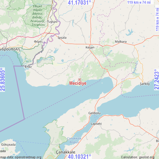
Mecidiye GPS coordinates[2]
40° 38' 20.004" North, 26° 32' 21.012" East
| Map corner | latitude | longitude |
|---|---|---|
| Upper-left | 41.17031°, | 25.83605° |
| Center: | 40.63889°, | 26.53917° |
| Lower-right: | 40.10321°, | 27.2423° |
| Map W x H: | 118.7×118.6 km | = 73.8×73.7mi |
| max Lat: | 42.02683° ⇑20.4% North |
| Mecidiye: | 40.63889° |
| min Lat: | ⇓79.6% South 35.9025° |
| min Long | Mecidiye | max Long |
| 25.90902° | 26.53917° | 44.60099° |
| W 1%⇐ | ⇒99% E |
Elevation
Elevation of Mecidiye is 38 m = 125 ft, and this is 679.4 m = 2229 ft below average elevation for this country.
| Max E: |
2682 m = 8799 ft | 90.2% |
| Avg. | 717.4 m = 2354 ft | |
| Mecidiye | 38 m = 125 ft | |
Min E: |
0 m = 0 ft | 9.8% |
See also: Turkey elevation on elevation.city.
Geographical zone
Mecidiye is located in North temperate zone (between Tropic of Cancer and the Arctic Circle). Distance of this Northern Tropic circle is 1912.7 km =1188.5 mi to South.| Distance of | km | miles | from Mecidiye |
|---|---|---|---|
| North Pole | 5488.4 | 3410.3 | to North |
| Arctic Circle | 2882.6 | 1791.2 | to North |
| Tropic Cancer | 1912.7 | 1188.5 | to South |
| Equator | 4518.6 | 2807.7 | to South |


Nearby cities:
15 places around Mecidiye: (largest is in red/bold)
• Ballı
48.4 km =30.1 mi,  63°
63°
• Beyçayırı
53.7 km =33.4 mi,  142°
142°
• Bolayır
22.9 km =14.2 mi,  126°
126°
• Eceabat
52.9 km =32.9 mi,  196°
196°
• Enez
39.7 km =24.7 mi,  283°
283°
• Evreşe
29.2 km =18.1 mi,  83°
83°
• Gelibolu
27.7 km =17.2 mi,  156°
156°
• Keşan
25.3 km =15.7 mi,  17°
17°
• Lapseki
35 km =21.7 mi, 159°
• Malkara
41.3 km =25.7 mi,  47°
47°
• Umurbey
45.4 km =28.2 mi,  172°
172°
• İbriktepe
41.4 km =25.7 mi,  355°
355°
• İpsala
34 km =21.1 mi,  337°
337°
• Şahin
49.6 km =30.8 mi,  30°
30°
• Şarköy
48.7 km =30.3 mi,  93°
93°
Sources, notices
• [Note1] Compared only with cities in Turkey existing in our database
• [Src1] Map data: © OpenStreetMap contributors (CC-BY-SA)
• [Src2] Other city data from geonames.org with taken over terms of usage.
• [Src3] Geographical zone / Annual Mean Temperature by Robert A. Rohde @ Wikipedia
