Boyalık geodata
Boyalık (Istanbul) is a populated place; located in Turkey in Europe/Istanbul (GMT+3) time zone. With population of 11,835 people, there are 455 cities with bigger population in this country. Compared to other cities in Turkey, 95.2% of cities are located further ↓South; 86.3% of cities are located further →East and 83.4% of cities have higher elevation than Boyalık. Note1


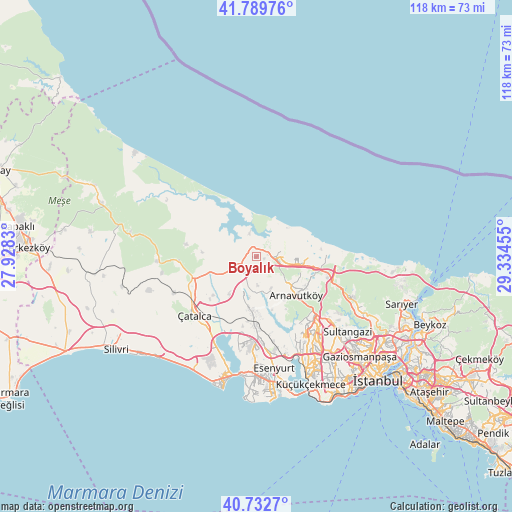
Boyalık GPS coordinates[2]
41° 15' 48.132" North, 28° 37' 53.112" East
| Map corner | latitude | longitude |
|---|---|---|
| Upper-left | 41.78976°, | 27.9283° |
| Center: | 41.26337°, | 28.63142° |
| Lower-right: | 40.7327°, | 29.33455° |
| Map W x H: | 117.5×117.5 km | = 73×73mi |
| max Lat: | 42.02683° ⇑4.8% North |
| Boyalık: | 41.26337° |
| min Lat: | ⇓95.2% South 35.9025° |
| min Long | Boyalık | max Long |
| 25.90902° | 28.63142° | 44.60099° |
| W 13.7%⇐ | ⇒86.3% E |
Elevation
Elevation of Boyalık is 83 m = 272 ft, and this is 634.4 m = 2081 ft below average elevation for this country.
| Max E: |
2682 m = 8799 ft | 83.4% |
| Avg. | 717.4 m = 2354 ft | |
| Boyalık | 83 m = 272 ft | |
Min E: |
0 m = 0 ft | 16.6% |
See also: Turkey elevation on elevation.city.
Geographical zone
Boyalık is located in North temperate zone (between Tropic of Cancer and the Arctic Circle). Distance of this Northern Tropic circle is 1982.1 km =1231.6 mi to South.| Distance of | km | miles | from Boyalık |
|---|---|---|---|
| North Pole | 5419 | 3367.2 | to North |
| Arctic Circle | 2813.1 | 1748 | to North |
| Tropic Cancer | 1982.1 | 1231.6 | to South |
| Equator | 4588.1 | 2850.9 | to South |


Nearby cities:
15 places around Boyalık: (largest is in red/bold)
• Arnavutköy
12.7 km =7.9 mi,  134°
134°
• Başakşehir
23.7 km =14.7 mi,  142°
142°
• Büyükçekmece
27.3 km =17 mi,  188°
188°
• Chekmejeh
28.9 km =18 mi,  195°
195°
• Durusu
5.8 km =3.6 mi,  40°
40°
• Esenyurt
26.6 km =16.5 mi,  171°
171°
• Karacaköy
26.1 km =16.2 mi,  306°
306°
• Kemerburgaz
26.5 km =16.5 mi,  116°
116°
• Mahmutbey
28.4 km =17.6 mi,  145°
145°
• Mimarsinan
27.9 km =17.3 mi, 192°
• Muratbey
21.9 km =13.6 mi,  212°
212°
• Ortaköy
27.9 km =17.3 mi,  229°
229°
• Sultangazi
26.4 km =16.4 mi, 131°
• Tepecik
26.9 km =16.7 mi, 194°
• Çatalca
19.5 km =12.1 mi, 226°
Sources, notices
• [Note1] Compared only with cities in Turkey existing in our database
• [Src1] Map data: © OpenStreetMap contributors (CC-BY-SA)
• [Src2] Other city data from geonames.org with taken over terms of usage.
• [Src3] Geographical zone / Annual Mean Temperature by Robert A. Rohde @ Wikipedia
