Akyaka geodata
Akyaka (Kars) is a seat of a second-order administrative division; located in Turkey in Europe/Istanbul (GMT+3) time zone. In our database, there are 1323 cities with bigger population. Compared to other cities in Turkey, 82.1% of cities are located further ↓South; 98.9% of cities are located further ←West and 90.8% of cities have lower elevation than Akyaka. Note1


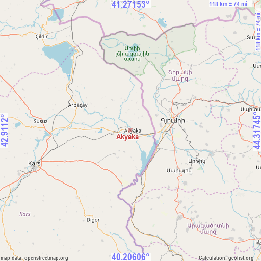
Akyaka GPS coordinates[2]
40° 44' 27.348" North, 43° 36' 51.552" East
| Map corner | latitude | longitude |
|---|---|---|
| Upper-left | 41.27153°, | 42.9112° |
| Center: | 40.74093°, | 43.61432° |
| Lower-right: | 40.20606°, | 44.31745° |
| Map W x H: | 118.5×118.5 km | = 73.6×73.6mi |
| max Lat: | 42.02683° ⇑17.9% North |
| Akyaka: | 40.74093° |
| min Lat: | ⇓82.1% South 35.9025° |
| min Long | Akyaka | max Long |
| 25.90902° | 43.61432° | 44.60099° |
| W 98.9%⇐ | ⇒1.1% E |
Elevation
Elevation of Akyaka is 1502 m = 4928 ft, and this is 784.6 m = 2574 ft above average elevation for this country.
| Max E: |
2682 m = 8799 ft | 9.2% |
| Akyaka | 1502 m 4928 ft | |
| Avg. | 717.4 m = 2354 ft | |
Min E: |
0 m = 0 ft | 90.8% |
See also: Turkey elevation on elevation.city.
Geographical zone
Akyaka is located in North temperate zone (between Tropic of Cancer and the Arctic Circle). Distance of this Northern Tropic circle is 1924 km =1195.5 mi to South.| Distance of | km | miles | from Akyaka |
|---|---|---|---|
| North Pole | 5477.1 | 3403.3 | to North |
| Arctic Circle | 2871.2 | 1784.1 | to North |
| Tropic Cancer | 1924 | 1195.5 | to South |
| Equator | 4530 | 2814.8 | to South |


Nearby cities:
15 places around Akyaka: (largest is in red/bold)
• Arpaçay
26.8 km =16.7 mi,  295°
295°
• Başgedikler
13.6 km =8.5 mi,  214°
214°
• Digor
44.8 km =27.8 mi,  202°
202°
• Doğruyol
29.2 km =18.1 mi,  335°
335°
• Doğruyol
43.3 km =26.9 mi,  325°
325°
• Gaziler
74.6 km =46.4 mi,  190°
190°
• Hasköy
67.4 km =41.9 mi,  294°
294°
• Kars
47.3 km =29.4 mi,  250°
250°
• Kağızman
76.6 km =47.6 mi, 212°
• Kurtkale
71.3 km =44.3 mi,  324°
324°
• Kötek
77.8 km =48.3 mi,  221°
221°
• Selim
76.9 km =47.8 mi, 245°
• Susuz
41.2 km =25.6 mi,  275°
275°
• Tuzluca
78.1 km =48.5 mi,  177°
177°
• Zurzuna
58.7 km =36.5 mi, 316°
Sources, notices
• [Note1] Compared only with cities in Turkey existing in our database
• [Src1] Map data: © OpenStreetMap contributors (CC-BY-SA)
• [Src2] Other city data from geonames.org with taken over terms of usage.
• [Src3] Geographical zone / Annual Mean Temperature by Robert A. Rohde @ Wikipedia
