Gaziler geodata
Gaziler (Iğdır) is a seat of a third-order administrative division; located in Turkey in Europe/Istanbul (GMT+3) time zone. In our database, there are 1323 cities with bigger population. Compared to other cities in Turkey, 70.6% of cities are located further ↓South; 98.5% of cities are located further ←West and 75.4% of cities have lower elevation than Gaziler. Note1


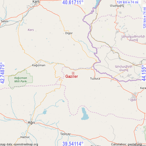
Gaziler GPS coordinates[2]
40° 4' 52.5" North, 43° 27' 6.732" East
| Map corner | latitude | longitude |
|---|---|---|
| Upper-left | 40.61711°, | 42.74875° |
| Center: | 40.08125°, | 43.45187° |
| Lower-right: | 39.54114°, | 44.155° |
| Map W x H: | 119.6×119.6 km | = 74.3×74.3mi |
| max Lat: | 42.02683° ⇑29.4% North |
| Gaziler: | 40.08125° |
| min Lat: | ⇓70.6% South 35.9025° |
| min Long | Gaziler | max Long |
| 25.90902° | 43.45187° | 44.60099° |
| W 98.5%⇐ | ⇒1.5% E |
Elevation
Elevation of Gaziler is 1114 m = 3655 ft, and this is 396.6 m = 1301 ft above average elevation for this country.
| Max E: |
2682 m = 8799 ft | 24.6% |
| Gaziler | 1114 m 3655 ft | |
| Avg. | 717.4 m = 2354 ft | |
Min E: |
0 m = 0 ft | 75.4% |
See also: Turkey elevation on elevation.city.
Geographical zone
Gaziler is located in North temperate zone (between Tropic of Cancer and the Arctic Circle). Distance of this Northern Tropic circle is 1850.7 km =1150 mi to South.| Distance of | km | miles | from Gaziler |
|---|---|---|---|
| North Pole | 5550.4 | 3448.9 | to North |
| Arctic Circle | 2944.6 | 1829.7 | to North |
| Tropic Cancer | 1850.7 | 1150 | to South |
| Equator | 4456.6 | 2769.2 | to South |


Nearby cities:
15 places around Gaziler: (largest is in red/bold)
• Ağrı
52.8 km =32.8 mi,  220°
220°
• Başgedikler
62.5 km =38.8 mi,  5°
5°
• Cumaçay
29.2 km =18.1 mi,  230°
230°
• Digor
32.2 km =20 mi,  353°
353°
• Diyadin
63 km =39.1 mi,  162°
162°
• Hamur
66.2 km =41.1 mi, 217°
• Iğdır
53.5 km =33.2 mi,  109°
109°
• Karakoyunlu
27.9 km =17.3 mi,  147°
147°
• Kars
65.3 km =40.6 mi,  331°
331°
• Kağızman
28.3 km =17.6 mi,  287°
287°
• Kötek
41.2 km =25.6 mi, 291°
• Murat
48.9 km =30.4 mi,  201°
201°
• Suluçem
53 km =32.9 mi,  144°
144°
• Taşlıçay
50.7 km =31.5 mi,  188°
188°
• Tuzluca
17.7 km =11 mi, 105°
Sources, notices
• [Note1] Compared only with cities in Turkey existing in our database
• [Src1] Map data: © OpenStreetMap contributors (CC-BY-SA)
• [Src2] Other city data from geonames.org with taken over terms of usage.
• [Src3] Geographical zone / Annual Mean Temperature by Robert A. Rohde @ Wikipedia
