Kötek geodata
Kötek (Kars) is a seat of a third-order administrative division; located in Turkey in Europe/Istanbul (GMT+3) time zone. In our database, there are 1323 cities with bigger population. Compared to other cities in Turkey, 73% of cities are located further ↓South; 96.6% of cities are located further ←West and 89.1% of cities have lower elevation than Kötek. Note1


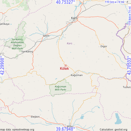
Kötek GPS coordinates[2]
40° 13' 6.6" North, 43° 0' 7.92" East
| Map corner | latitude | longitude |
|---|---|---|
| Upper-left | 40.75327°, | 42.29908° |
| Center: | 40.2185°, | 43.0022° |
| Lower-right: | 39.67948°, | 43.70533° |
| Map W x H: | 119.4×119.4 km | = 74.2×74.2mi |
| max Lat: | 42.02683° ⇑27% North |
| Kötek: | 40.2185° |
| min Lat: | ⇓73% South 35.9025° |
| min Long | Kötek | max Long |
| 25.90902° | 43.0022° | 44.60099° |
| W 96.6%⇐ | ⇒3.4% E |
Elevation
Elevation of Kötek is 1435 m = 4708 ft, and this is 717.6 m = 2354 ft above average elevation for this country.
| Max E: |
2682 m = 8799 ft | 10.9% |
| Kötek | 1435 m 4708 ft | |
| Avg. | 717.4 m = 2354 ft | |
Min E: |
0 m = 0 ft | 89.1% |
See also: Turkey elevation on elevation.city.
Geographical zone
Kötek is located in North temperate zone (between Tropic of Cancer and the Arctic Circle). Distance of this Northern Tropic circle is 1866 km =1159.5 mi to South.| Distance of | km | miles | from Kötek |
|---|---|---|---|
| North Pole | 5535.2 | 3439.4 | to North |
| Arctic Circle | 2929.3 | 1820.2 | to North |
| Tropic Cancer | 1866 | 1159.5 | to South |
| Equator | 4471.9 | 2778.7 | to South |


Nearby cities:
15 places around Kötek: (largest is in red/bold)
• Ağrı
55.6 km =34.5 mi,  175°
175°
• Cumaçay
37.2 km =23.1 mi,  155°
155°
• Digor
38.4 km =23.9 mi,  64°
64°
• Eleşkirt
54.4 km =33.8 mi,  210°
210°
• Gaziler
41.2 km =25.6 mi,  111°
111°
• Gaziler
59.9 km =37.2 mi,  292°
292°
• Karakurt
34.3 km =21.3 mi,  260°
260°
• Karaurgan
62 km =38.5 mi,  272°
272°
• Kars
42.8 km =26.6 mi,  9°
9°
• Kağızman
13.2 km =8.2 mi,  121°
121°
• Sarıkamış
37.3 km =23.2 mi, 289°
• Selim
32.5 km =20.2 mi,  325°
325°
• Susuz
63.2 km =39.3 mi, 9°
• Tahir
63.3 km =39.3 mi,  230°
230°
• Tuzluca
58.8 km =36.5 mi, 109°
Sources, notices
• [Note1] Compared only with cities in Turkey existing in our database
• [Src1] Map data: © OpenStreetMap contributors (CC-BY-SA)
• [Src2] Other city data from geonames.org with taken over terms of usage.
• [Src3] Geographical zone / Annual Mean Temperature by Robert A. Rohde @ Wikipedia
