Kağızman geodata
Kağızman (Kars) is a seat of a second-order administrative division; located in Turkey in Europe/Istanbul (GMT+3) time zone. With population of 25,157 people, there are 283 cities with bigger population in this country. Compared to other cities in Turkey, 71.6% of cities are located further ↓South; 97.5% of cities are located further ←West and 83.6% of cities have lower elevation than Kağızman. Note1


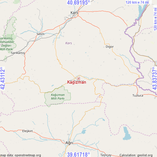
Kağızman GPS coordinates[2]
40° 9' 24.084" North, 43° 8' 3.264" East
| Map corner | latitude | longitude |
|---|---|---|
| Upper-left | 40.69195°, | 42.43112° |
| Center: | 40.15669°, | 43.13424° |
| Lower-right: | 39.61718°, | 43.83737° |
| Map W x H: | 119.5×119.5 km | = 74.3×74.3mi |
| max Lat: | 42.02683° ⇑28.4% North |
| Kağızman: | 40.15669° |
| min Lat: | ⇓71.6% South 35.9025° |
| min Long | Kağızman | max Long |
| 25.90902° | 43.13424° | 44.60099° |
| W 97.5%⇐ | ⇒2.5% E |
Elevation
Elevation of Kağızman is 1276 m = 4186 ft, and this is 558.6 m = 1833 ft above average elevation for this country.
| Max E: |
2682 m = 8799 ft | 16.4% |
| Kağızman | 1276 m 4186 ft | |
| Avg. | 717.4 m = 2354 ft | |
Min E: |
0 m = 0 ft | 83.6% |
See also: Turkey elevation on elevation.city.
Geographical zone
Kağızman is located in North temperate zone (between Tropic of Cancer and the Arctic Circle). Distance of this Northern Tropic circle is 1859.1 km =1155.2 mi to South.| Distance of | km | miles | from Kağızman |
|---|---|---|---|
| North Pole | 5542.1 | 3443.7 | to North |
| Arctic Circle | 2936.2 | 1824.5 | to North |
| Tropic Cancer | 1859.1 | 1155.2 | to South |
| Equator | 4465 | 2774.4 | to South |


Nearby cities:
15 places around Kağızman: (largest is in red/bold)
• Ağrı
49.1 km =30.5 mi,  188°
188°
• Cumaçay
27.2 km =16.9 mi,  170°
170°
• Digor
33.2 km =20.6 mi,  44°
44°
• Eleşkirt
55.8 km =34.7 mi,  224°
224°
• Gaziler
28.3 km =17.6 mi,  107°
107°
• Hamur
62.6 km =38.9 mi, 191°
• Karakoyunlu
52.9 km =32.9 mi,  127°
127°
• Karakurt
45 km =28 mi,  271°
271°
• Kars
49.3 km =30.6 mi,  355°
355°
• Kötek
13.2 km =8.2 mi,  301°
301°
• Murat
54.5 km =33.9 mi, 170°
• Sarıkamış
50.2 km =31.2 mi,  292°
292°
• Selim
44.8 km =27.8 mi,  318°
318°
• Taşlıçay
61.9 km =38.5 mi,  161°
161°
• Tuzluca
46 km =28.6 mi, 106°
Sources, notices
• [Note1] Compared only with cities in Turkey existing in our database
• [Src1] Map data: © OpenStreetMap contributors (CC-BY-SA)
• [Src2] Other city data from geonames.org with taken over terms of usage.
• [Src3] Geographical zone / Annual Mean Temperature by Robert A. Rohde @ Wikipedia
