Chake Chake geodata
Chake Chake (Pemba South) is a seat of a first-order administrative division; located in Tanzania in Africa/Dar_es_Salaam (GMT+3) time zone. With population of 21,686 people, there are 113 cities with bigger population in this country. Compared to other cities in Tanzania, 50.3% of cities are located further ↑North; 98.6% of cities are located further ←West and 96.5% of cities have higher elevation than Chake Chake. Note1


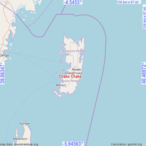
Chake Chake GPS coordinates[2]
5° 14' 45.096" South, 39° 45' 59.724" East
| Map corner | latitude | longitude |
|---|---|---|
| Upper-left | -4.5453°, | 39.06347° |
| Center: | -5.24586°, | 39.76659° |
| Lower-right: | -5.94563°, | 40.46972° |
| Map W x H: | 155.7×155.7 km | = 96.7×96.7mi |
| max Lat: | -1.14389° ⇑50.3% North |
| Chake Chake: | -5.24586° |
| min Lat: | ⇓49.7% South -11.36667° |
| min Long | Chake Chake | max Long |
| 29.62667° | 39.76659° | 40.33333° |
| W 98.6%⇐ | ⇒1.4% E |
Elevation
Elevation of Chake Chake is 19 m = 62 ft, and this is 923.8 m = 3031 ft below average elevation for this country.
| Max E: |
2377 m = 7799 ft | 96.5% |
| Avg. | 942.8 m = 3093 ft | |
| Chake Chake | 19 m = 62 ft | |
Min E: |
0 m = 0 ft | 3.5% |
See also: Tanzania elevation on elevation.city.
Geographical zone
Chake Chake is located in South Torrid zone (between Equator and Tropic of Capricorn). Distance of Equator is 583.3 km =362.4 mi to North.| Distance of | km | miles | from Chake Chake |
|---|---|---|---|
| Equator | 583.3 | 362.4 | to North |
| Tropic Capricorn | 2022.6 | 1256.8 | to South |
| Antarctic Circle | 6817.9 | 4236.4 | to South |
| South Pole | 9423.8 | 5855.7 | to South |


Nearby cities:
15 places around Chake Chake: (largest is in red/bold)
• Gamba
89.2 km =55.4 mi,  215°
215°
• Kijini
83.6 km =51.9 mi, 216°
• Kiwengwa
93.3 km =58 mi,  207°
207°
• Konde
32.9 km =20.4 mi,  356°
356°
• Majengo
87.4 km =54.3 mi,  277°
277°
• Micheweni
31.9 km =19.8 mi,  13°
13°
• Mkokotoni
90 km =55.9 mi, 218°
• Mlalo
98.6 km =61.3 mi,  290°
290°
• Mtambile
17 km =10.6 mi, 205°
• Muheza
109.2 km =67.9 mi,  274°
274°
• Nungwi
74.4 km =46.2 mi, 224°
• Pangani
89.9 km =55.9 mi,  257°
257°
• Tanga
76.5 km =47.5 mi, 284°
• Uwelini
19.5 km =12.1 mi, 208°
• Wete
21.5 km =13.4 mi,  348°
348°
Sources, notices
• [Note1] Compared only with cities in Tanzania existing in our database
• [Src1] Map data: © OpenStreetMap contributors (CC-BY-SA)
• [Src2] Other city data from geonames.org with taken over terms of usage.
• [Src3] Geographical zone / Annual Mean Temperature by Robert A. Rohde @ Wikipedia
