Micheweni geodata
Micheweni (Pemba North) is a populated place; located in Tanzania in Africa/Dar_es_Salaam (GMT+3) time zone. With population of 9,838 people, there are 240 cities with bigger population in this country. Compared to other cities in Tanzania, 55.6% of cities are located further ↓South; 99% of cities are located further ←West and 100% of cities have higher elevation than Micheweni. Note1


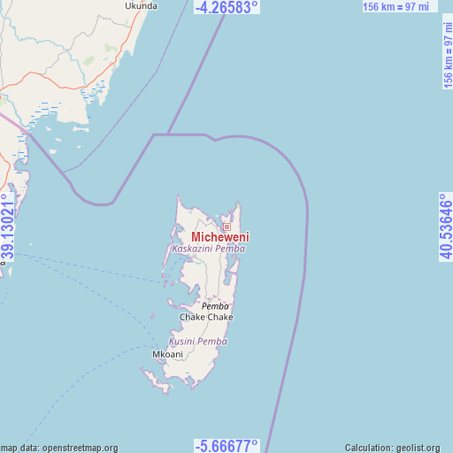
Micheweni GPS coordinates[2]
4° 58' 0.012" South, 39° 49' 59.988" East
| Map corner | latitude | longitude |
|---|---|---|
| Upper-left | -4.26583°, | 39.13021° |
| Center: | -4.96667°, | 39.83333° |
| Lower-right: | -5.66677°, | 40.53646° |
| Map W x H: | 155.8×155.8 km | = 96.8×96.8mi |
| max Lat: | -1.14389° ⇑44.4% North |
| Micheweni: | -4.96667° |
| min Lat: | ⇓55.6% South -11.36667° |
| min Long | Micheweni | max Long |
| 29.62667° | 39.83333° | 40.33333° |
| W 99%⇐ | ⇒1% E |
Elevation
Elevation of Micheweni is 0 m = 0 ft, and this is 942.8 m = 3093 ft below average elevation for this country.
| Max E: |
2377 m = 7799 ft | 100% |
| Avg. | 942.8 m = 3093 ft | |
| Micheweni | 0 m = 0 ft | |
Min E: |
0 m = 0 ft | 0% |
See also: Tanzania elevation on elevation.city.
Geographical zone
Micheweni is located in South Torrid zone (between Equator and Tropic of Capricorn). Distance of Equator is 552.2 km =343.1 mi to North.| Distance of | km | miles | from Micheweni |
|---|---|---|---|
| Equator | 552.2 | 343.1 | to North |
| Tropic Capricorn | 2053.7 | 1276.1 | to South |
| Antarctic Circle | 6848.9 | 4255.7 | to South |
| South Pole | 9454.8 | 5874.9 | to South |


Nearby cities:
15 places around Micheweni: (largest is in red/bold)
• Chake Chake
31.9 km =19.8 mi,  193°
193°
• Gamba
119.4 km =74.2 mi,  209°
209°
• Kijini
113.7 km =70.6 mi, 210°
• Kiwengwa
124.5 km =77.4 mi,  203°
203°
• Konde
9.4 km =5.8 mi,  281°
281°
• Majengo
96.3 km =59.8 mi,  257°
257°
• Mkokotoni
119.6 km =74.3 mi, 212°
• Mlalo
99.8 km =62 mi,  272°
272°
• Mtambile
48.6 km =30.2 mi, 197°
• Muheza
118.4 km =73.6 mi, 259°
• Nungwi
103.2 km =64.1 mi,  215°
215°
• Pangani
107.9 km =67 mi,  241°
241°
• Tanga
82.2 km =51.1 mi, 262°
• Uwelini
51 km =31.7 mi, 199°
• Wete
15.2 km =9.4 mi,  229°
229°
Sources, notices
• [Note1] Compared only with cities in Tanzania existing in our database
• [Src1] Map data: © OpenStreetMap contributors (CC-BY-SA)
• [Src2] Other city data from geonames.org with taken over terms of usage.
• [Src3] Geographical zone / Annual Mean Temperature by Robert A. Rohde @ Wikipedia
