Songwa geodata
Songwa (Shinyanga) is a populated place; located in Tanzania in Africa/Dar_es_Salaam (GMT+3) time zone. With population of 23,618 people, there are 98 cities with bigger population in this country. Compared to other cities in Tanzania, 76.6% of cities are located further ↓South; 73.8% of cities are located further →East and 52.8% of cities have lower elevation than Songwa. Note1


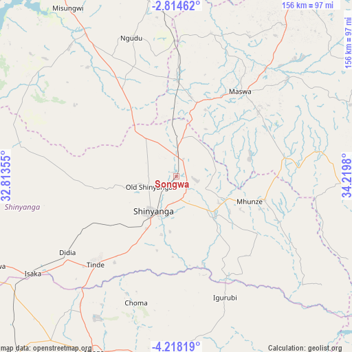
Songwa GPS coordinates[2]
3° 31' 0.012" South, 33° 31' 0.012" East
| Map corner | latitude | longitude |
|---|---|---|
| Upper-left | -2.81462°, | 32.81355° |
| Center: | -3.51667°, | 33.51667° |
| Lower-right: | -4.21819°, | 34.2198° |
| Map W x H: | 156.1×156.1 km | = 97×97mi |
| max Lat: | -1.14389° ⇑23.4% North |
| Songwa: | -3.51667° |
| min Lat: | ⇓76.6% South -11.36667° |
| min Long | Songwa | max Long |
| 29.62667° | 33.51667° | 40.33333° |
| W 26.2%⇐ | ⇒73.8% E |
Elevation
Elevation of Songwa is 1149 m = 3770 ft, and this is 206.2 m = 677 ft above average elevation for this country.
| Max E: |
2377 m = 7799 ft | 47.2% |
| Songwa | 1149 m 3770 ft | |
| Avg. | 942.8 m = 3093 ft | |
Min E: |
0 m = 0 ft | 52.8% |
See also: Tanzania elevation on elevation.city.
Geographical zone
Songwa is located in South Torrid zone (between Equator and Tropic of Capricorn). Distance of Equator is 391 km =243 mi to North.| Distance of | km | miles | from Songwa |
|---|---|---|---|
| Equator | 391 | 243 | to North |
| Tropic Capricorn | 2214.9 | 1376.3 | to South |
| Antarctic Circle | 7010.2 | 4355.9 | to South |
| South Pole | 9616 | 5975.1 | to South |


Nearby cities:
15 places around Songwa: (largest is in red/bold)
• Igurubi
57.5 km =35.7 mi,  159°
159°
• Isaka
77.5 km =48.2 mi,  236°
236°
• Kishapu
40.4 km =25.1 mi,  105°
105°
• Lalago
48.7 km =30.3 mi,  81°
81°
• Malampaka
42.7 km =26.5 mi,  2°
2°
• Malya
59.3 km =36.8 mi, 0°
• Mhango
78.4 km =48.7 mi,  289°
289°
• Misasi
74.9 km =46.5 mi,  320°
320°
• Mwadui
10 km =6.2 mi, 111°
• Ngudu
64.5 km =40.1 mi,  341°
341°
• Nyalikungu
47.4 km =29.5 mi,  38°
38°
• Old Shinyanga
13.5 km =8.4 mi,  254°
254°
• Shinyanga
19.5 km =12.1 mi,  212°
212°
• Somanda
50.9 km =31.6 mi,  70°
70°
• Tinde
53.8 km =33.4 mi,  220°
220°
Sources, notices
• [Note1] Compared only with cities in Tanzania existing in our database
• [Src1] Map data: © OpenStreetMap contributors (CC-BY-SA)
• [Src2] Other city data from geonames.org with taken over terms of usage.
• [Src3] Geographical zone / Annual Mean Temperature by Robert A. Rohde @ Wikipedia
