Lalago geodata
Lalago (Simiyu) is a populated place; located in Tanzania in Africa/Dar_es_Salaam (GMT+3) time zone. With population of 22,551 people, there are 108 cities with bigger population in this country. Compared to other cities in Tanzania, 77.3% of cities are located further ↓South; 66.8% of cities are located further →East and 58% of cities have lower elevation than Lalago. Note1


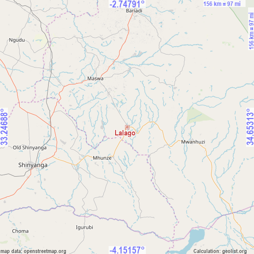
Lalago GPS coordinates[2]
3° 27' 0" South, 33° 57' 0" East
| Map corner | latitude | longitude |
|---|---|---|
| Upper-left | -2.74791°, | 33.24688° |
| Center: | -3.45°, | 33.95° |
| Lower-right: | -4.15157°, | 34.65313° |
| Map W x H: | 156.1×156.1 km | = 97×97mi |
| max Lat: | -1.14389° ⇑22.7% North |
| Lalago: | -3.45° |
| min Lat: | ⇓77.3% South -11.36667° |
| min Long | Lalago | max Long |
| 29.62667° | 33.95° | 40.33333° |
| W 33.2%⇐ | ⇒66.8% E |
Elevation
Elevation of Lalago is 1176 m = 3858 ft, and this is 233.2 m = 765 ft above average elevation for this country.
| Max E: |
2377 m = 7799 ft | 42% |
| Lalago | 1176 m 3858 ft | |
| Avg. | 942.8 m = 3093 ft | |
Min E: |
0 m = 0 ft | 58% |
See also: Tanzania elevation on elevation.city.
Geographical zone
Lalago is located in South Torrid zone (between Equator and Tropic of Capricorn). Distance of Equator is 383.6 km =238.4 mi to North.| Distance of | km | miles | from Lalago |
|---|---|---|---|
| Equator | 383.6 | 238.4 | to North |
| Tropic Capricorn | 2222.3 | 1380.9 | to South |
| Antarctic Circle | 7017.6 | 4360.5 | to South |
| South Pole | 9623.5 | 5979.8 | to South |


Nearby cities:
15 places around Lalago: (largest is in red/bold)
• Bariadi
72.4 km =45 mi,  2°
2°
• Igurubi
67.2 km =41.8 mi,  204°
204°
• Kisesa
46.4 km =28.8 mi,  28°
28°
• Kishapu
20.7 km =12.9 mi,  206°
206°
• Malampaka
58.1 km =36.1 mi,  307°
307°
• Malya
70.8 km =44 mi,  317°
317°
• Maswa
85.3 km =53 mi, 2°
• Mwadui
40.4 km =25.1 mi,  254°
254°
• Ngudu
87 km =54.1 mi, 308°
• Nyakabindi
90.9 km =56.5 mi, 2°
• Nyalikungu
34.9 km =21.7 mi,  328°
328°
• Old Shinyanga
62 km =38.5 mi,  259°
259°
• Shinyanga
63.3 km =39.3 mi, 247°
• Somanda
9.3 km =5.8 mi, 0°
• Songwa
48.7 km =30.3 mi, 261°
Sources, notices
• [Note1] Compared only with cities in Tanzania existing in our database
• [Src1] Map data: © OpenStreetMap contributors (CC-BY-SA)
• [Src2] Other city data from geonames.org with taken over terms of usage.
• [Src3] Geographical zone / Annual Mean Temperature by Robert A. Rohde @ Wikipedia
