Kishapu geodata
Kishapu (Shinyanga) is a populated place; located in Tanzania in Africa/Dar_es_Salaam (GMT+3) time zone. With population of 16,371 people, there are 173 cities with bigger population in this country. Compared to other cities in Tanzania, 74.1% of cities are located further ↓South; 68.2% of cities are located further →East and 57% of cities have lower elevation than Kishapu. Note1


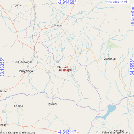
Kishapu GPS coordinates[2]
3° 37' 0.012" South, 33° 52' 0.012" East
| Map corner | latitude | longitude |
|---|---|---|
| Upper-left | -2.91469°, | 33.16355° |
| Center: | -3.61667°, | 33.86667° |
| Lower-right: | -4.31811°, | 34.5698° |
| Map W x H: | 156×156 km | = 96.9×96.9mi |
| max Lat: | -1.14389° ⇑25.9% North |
| Kishapu: | -3.61667° |
| min Lat: | ⇓74.1% South -11.36667° |
| min Long | Kishapu | max Long |
| 29.62667° | 33.86667° | 40.33333° |
| W 31.8%⇐ | ⇒68.2% E |
Elevation
Elevation of Kishapu is 1169 m = 3835 ft, and this is 226.2 m = 742 ft above average elevation for this country.
| Max E: |
2377 m = 7799 ft | 43% |
| Kishapu | 1169 m 3835 ft | |
| Avg. | 942.8 m = 3093 ft | |
Min E: |
0 m = 0 ft | 57% |
See also: Tanzania elevation on elevation.city.
Geographical zone
Kishapu is located in South Torrid zone (between Equator and Tropic of Capricorn). Distance of Equator is 402.1 km =249.9 mi to North.| Distance of | km | miles | from Kishapu |
|---|---|---|---|
| Equator | 402.1 | 249.9 | to North |
| Tropic Capricorn | 2203.8 | 1369.4 | to South |
| Antarctic Circle | 6999 | 4349 | to South |
| South Pole | 9604.9 | 5968.2 | to South |


Nearby cities:
15 places around Kishapu: (largest is in red/bold)
• Igunga
74.1 km =46 mi,  178°
178°
• Igurubi
46.5 km =28.9 mi,  203°
203°
• Kiomboi
91.1 km =56.6 mi,  142°
142°
• Kisesa
67.1 km =41.7 mi,  27°
27°
• Lalago
20.7 km =12.9 mi, 26°
• Malampaka
65.2 km =40.5 mi,  325°
325°
• Malya
80.4 km =50 mi, 331°
• Mwadui
30.5 km =19 mi,  284°
284°
• Nyalikungu
49.1 km =30.5 mi,  349°
349°
• Old Shinyanga
52.3 km =32.5 mi, 278°
• Shelui
91.2 km =56.7 mi,  156°
156°
• Shinyanga
49.7 km =30.9 mi,  263°
263°
• Somanda
29.3 km =18.2 mi,  18°
18°
• Songwa
40.4 km =25.1 mi,  285°
285°
• Tinde
79.7 km =49.5 mi,  248°
248°
Sources, notices
• [Note1] Compared only with cities in Tanzania existing in our database
• [Src1] Map data: © OpenStreetMap contributors (CC-BY-SA)
• [Src2] Other city data from geonames.org with taken over terms of usage.
• [Src3] Geographical zone / Annual Mean Temperature by Robert A. Rohde @ Wikipedia
