Igurubi geodata
Igurubi (Tabora) is a populated place; located in Tanzania in Africa/Dar_es_Salaam (GMT+3) time zone. With population of 10,083 people, there are 237 cities with bigger population in this country. Compared to other cities in Tanzania, 70.6% of cities are located further ↓South; 71% of cities are located further →East and 54.2% of cities have higher elevation than Igurubi. Note1


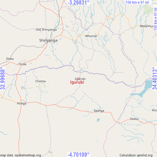
Igurubi GPS coordinates[2]
4° 0' 0" South, 33° 42' 0" East
| Map corner | latitude | longitude |
|---|---|---|
| Upper-left | -3.29831°, | 32.99688° |
| Center: | -4°, | 33.7° |
| Lower-right: | -4.70109°, | 34.40313° |
| Map W x H: | 156×156 km | = 96.9×96.9mi |
| max Lat: | -1.14389° ⇑29.4% North |
| Igurubi: | -4° |
| min Lat: | ⇓70.6% South -11.36667° |
| min Long | Igurubi | max Long |
| 29.62667° | 33.7° | 40.33333° |
| W 29%⇐ | ⇒71% E |
Elevation
Elevation of Igurubi is 1087 m = 3566 ft, and this is 144.2 m = 473 ft above average elevation for this country.
| Max E: |
2377 m = 7799 ft | 54.2% |
| Igurubi | 1087 m 3566 ft | |
| Avg. | 942.8 m = 3093 ft | |
Min E: |
0 m = 0 ft | 45.8% |
See also: Tanzania elevation on elevation.city.
Geographical zone
Igurubi is located in South Torrid zone (between Equator and Tropic of Capricorn). Distance of Equator is 444.8 km =276.4 mi to North.| Distance of | km | miles | from Igurubi |
|---|---|---|---|
| Equator | 444.8 | 276.4 | to North |
| Tropic Capricorn | 2161.2 | 1342.9 | to South |
| Antarctic Circle | 6956.4 | 4322.5 | to South |
| South Pole | 9562.3 | 5941.7 | to South |


Nearby cities:
15 places around Igurubi: (largest is in red/bold)
• Bukene
94.2 km =58.5 mi,  254°
254°
• Igunga
37.5 km =23.3 mi,  147°
147°
• Isaka
85.8 km =53.3 mi,  277°
277°
• Kiomboi
79.7 km =49.5 mi,  111°
111°
• Kishapu
46.5 km =28.9 mi,  23°
23°
• Lalago
67.2 km =41.8 mi, 24°
• Mwadui
51.3 km =31.9 mi,  347°
347°
• Nyalikungu
91.3 km =56.7 mi,  5°
5°
• Nzega
62.2 km =38.6 mi, 247°
• Old Shinyanga
60.1 km =37.3 mi,  326°
326°
• Shelui
68.8 km =42.8 mi,  126°
126°
• Shinyanga
48.5 km =30.1 mi,  320°
320°
• Somanda
75.7 km =47 mi, 21°
• Songwa
57.5 km =35.7 mi,  339°
339°
• Tinde
57 km =35.4 mi, 283°
Sources, notices
• [Note1] Compared only with cities in Tanzania existing in our database
• [Src1] Map data: © OpenStreetMap contributors (CC-BY-SA)
• [Src2] Other city data from geonames.org with taken over terms of usage.
• [Src3] Geographical zone / Annual Mean Temperature by Robert A. Rohde @ Wikipedia
