Mwadui geodata
Mwadui (Shinyanga) is a populated place; located in Tanzania in Africa/Dar_es_Salaam (GMT+3) time zone. With population of 23,296 people, there are 102 cities with bigger population in this country. Compared to other cities in Tanzania, 75.9% of cities are located further ↓South; 72.4% of cities are located further →East and 64.3% of cities have lower elevation than Mwadui. Note1


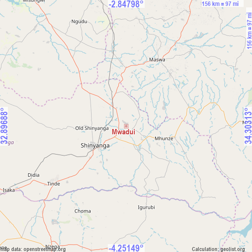
Mwadui GPS coordinates[2]
3° 33' 0" South, 33° 36' 0" East
| Map corner | latitude | longitude |
|---|---|---|
| Upper-left | -2.84798°, | 32.89688° |
| Center: | -3.55°, | 33.6° |
| Lower-right: | -4.25149°, | 34.30313° |
| Map W x H: | 156.1×156.1 km | = 97×97mi |
| max Lat: | -1.14389° ⇑24.1% North |
| Mwadui: | -3.55° |
| min Lat: | ⇓75.9% South -11.36667° |
| min Long | Mwadui | max Long |
| 29.62667° | 33.6° | 40.33333° |
| W 27.6%⇐ | ⇒72.4% E |
Elevation
Elevation of Mwadui is 1215 m = 3986 ft, and this is 272.2 m = 893 ft above average elevation for this country.
| Max E: |
2377 m = 7799 ft | 35.7% |
| Mwadui | 1215 m 3986 ft | |
| Avg. | 942.8 m = 3093 ft | |
Min E: |
0 m = 0 ft | 64.3% |
See also: Tanzania elevation on elevation.city.
Geographical zone
Mwadui is located in South Torrid zone (between Equator and Tropic of Capricorn). Distance of Equator is 394.7 km =245.3 mi to North.| Distance of | km | miles | from Mwadui |
|---|---|---|---|
| Equator | 394.7 | 245.3 | to North |
| Tropic Capricorn | 2211.2 | 1374 | to South |
| Antarctic Circle | 7006.5 | 4353.6 | to South |
| South Pole | 9612.3 | 5972.8 | to South |


Nearby cities:
15 places around Mwadui: (largest is in red/bold)
• Igurubi
51.3 km =31.9 mi,  167°
167°
• Isaka
83.6 km =51.9 mi,  242°
242°
• Kisesa
80.1 km =49.8 mi,  49°
49°
• Kishapu
30.5 km =19 mi,  104°
104°
• Lalago
40.4 km =25.1 mi,  74°
74°
• Malampaka
46.9 km =29.1 mi,  350°
350°
• Malya
63.7 km =39.6 mi, 351°
• Misasi
83.8 km =52.1 mi,  316°
316°
• Ngudu
71.3 km =44.3 mi,  335°
335°
• Nyalikungu
45.6 km =28.3 mi,  26°
26°
• Old Shinyanga
22.2 km =13.8 mi,  270°
270°
• Shinyanga
23.5 km =14.6 mi, 237°
• Somanda
43.9 km =27.3 mi,  62°
62°
• Songwa
10 km =6.2 mi,  291°
291°
• Tinde
57.8 km =35.9 mi,  230°
230°
Sources, notices
• [Note1] Compared only with cities in Tanzania existing in our database
• [Src1] Map data: © OpenStreetMap contributors (CC-BY-SA)
• [Src2] Other city data from geonames.org with taken over terms of usage.
• [Src3] Geographical zone / Annual Mean Temperature by Robert A. Rohde @ Wikipedia
