Moshi geodata
Moshi (Kilimanjaro) is a seat of a first-order administrative division; located in Tanzania in Africa/Dar_es_Salaam (GMT+3) time zone. With population of 156,959 people, there are 9 cities with bigger population in this country. Compared to other cities in Tanzania, 78.7% of cities are located further ↓South; 68.2% of cities are located further ←West and 62.6% of cities have higher elevation than Moshi. Note1


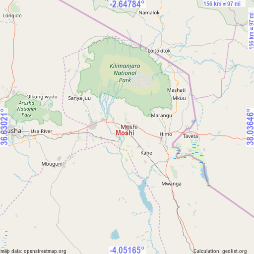
Moshi GPS coordinates[2]
3° 21' 0" South, 37° 19' 59.988" East
| Map corner | latitude | longitude |
|---|---|---|
| Upper-left | -2.64784°, | 36.63021° |
| Center: | -3.35°, | 37.33333° |
| Lower-right: | -4.05165°, | 38.03646° |
| Map W x H: | 156.1×156.1 km | = 97×97mi |
| max Lat: | -1.14389° ⇑21.3% North |
| Moshi: | -3.35° |
| min Lat: | ⇓78.7% South -11.36667° |
| min Long | Moshi | max Long |
| 29.62667° | 37.33333° | 40.33333° |
| W 68.2%⇐ | ⇒31.8% E |
Elevation
Elevation of Moshi is 854 m = 2802 ft, and this is 88.8 m = 291 ft below average elevation for this country.
| Max E: |
2377 m = 7799 ft | 62.6% |
| Avg. | 942.8 m = 3093 ft | |
| Moshi | 854 m = 2802 ft | |
Min E: |
0 m = 0 ft | 37.4% |
See also: Moshi elevation on elevation.city.
Geographical zone
Moshi is located in South Torrid zone (between Equator and Tropic of Capricorn). Distance of Equator is 372.5 km =231.5 mi to North.| Distance of | km | miles | from Moshi |
|---|---|---|---|
| Equator | 372.5 | 231.5 | to North |
| Tropic Capricorn | 2233.4 | 1387.8 | to South |
| Antarctic Circle | 7028.7 | 4367.4 | to South |
| South Pole | 9634.6 | 5986.7 | to South |


Nearby cities:
15 places around Moshi: (largest is in red/bold)
• Arusha
72.2 km =44.9 mi,  268°
268°
• Kingori
39.6 km =24.6 mi,  280°
280°
• Kirya
65.2 km =40.5 mi,  165°
165°
• Kwakoa
62.9 km =39.1 mi,  137°
137°
• Lembeni
57.5 km =35.7 mi,  146°
146°
• Longido
98.4 km =61.1 mi,  314°
314°
• Mbuguni
48.9 km =30.4 mi,  240°
240°
• Merelani
45.8 km =28.5 mi, 239°
• Monduli
98.2 km =61 mi, 273°
• Mwembe
105.8 km =65.7 mi, 147°
• Naberera
104.4 km =64.9 mi,  205°
205°
• Nkoaranga
59.2 km =36.8 mi, 271°
• Poli
59.2 km =36.8 mi, 271°
• Same
91.2 km =56.7 mi, 150°
• Usa River
53.7 km =33.4 mi, 268°
Sources, notices
• [Note1] Compared only with cities in Tanzania existing in our database
• [Src1] Map data: © OpenStreetMap contributors (CC-BY-SA)
• [Src2] Other city data from geonames.org with taken over terms of usage.
• [Src3] Geographical zone / Annual Mean Temperature by Robert A. Rohde @ Wikipedia
