Monduli geodata
Monduli (Arusha) is a populated place; located in Tanzania in Africa/Dar_es_Salaam (GMT+3) time zone. With population of 5,694 people, there are 268 cities with bigger population in this country. Compared to other cities in Tanzania, 80.4% of cities are located further ↓South; 60.1% of cities are located further ←West and 85.7% of cities have lower elevation than Monduli. Note1


Monduli GPS coordinates[2]
3° 18' 0" South, 36° 27' 0" East
| Map corner | latitude | longitude |
|---|---|---|
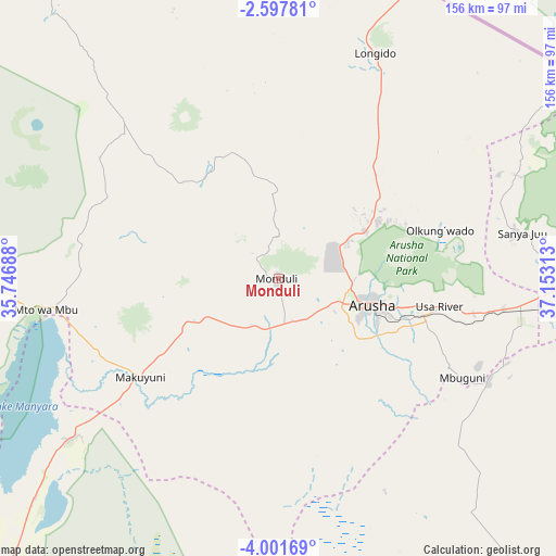
| Upper-left | -2.59781°, | 35.74688° |
| Center: | -3.3°, | 36.45° |
| Lower-right: | -4.00169°, | 37.15313° |
| Map W x H: | 156.1×156.1 km | = 97×97mi |
| max Lat: | -1.14389° ⇑19.6% North |
| Monduli: | -3.3° |
| min Lat: | ⇓80.4% South -11.36667° |
| min Long | Monduli | max Long |
| 29.62667° | 36.45° | 40.33333° |
| W 60.1%⇐ | ⇒39.9% E |
Elevation
Elevation of Monduli is 1534 m = 5033 ft, and this is 591.2 m = 1940 ft above average elevation for this country.
| Max E: |
2377 m = 7799 ft | 14.3% |
| Monduli | 1534 m 5033 ft | |
| Avg. | 942.8 m = 3093 ft | |
Min E: |
0 m = 0 ft | 85.7% |
See also: Tanzania elevation on elevation.city.
Geographical zone
Monduli is located in South Torrid zone (between Equator and Tropic of Capricorn). Distance of Equator is 366.9 km =228 mi to North.| Distance of | km | miles | from Monduli |
|---|---|---|---|
| Equator | 366.9 | 228 | to North |
| Tropic Capricorn | 2239 | 1391.2 | to South |
| Antarctic Circle | 7034.2 | 4370.8 | to South |
| South Pole | 9640.1 | 5990.1 | to South |


Nearby cities:
15 places around Monduli: (largest is in red/bold)
• Arusha
26.9 km =16.7 mi,  105°
105°
• Kingori
59.2 km =36.8 mi,  88°
88°
• Kiratu
87 km =54.1 mi,  267°
267°
• Longido
68.8 km =42.8 mi,  23°
23°
• Magugu
110 km =68.4 mi,  223°
223°
• Mbuguni
62.9 km =39.1 mi,  118°
118°
• Merelani
65.5 km =40.7 mi, 116°
• Moshi
98.2 km =61 mi, 93°
• Mto wa Mbu
66.8 km =41.5 mi, 265°
• Naberera
113.5 km =70.5 mi,  151°
151°
• Namanga
91.1 km =56.6 mi, 23°
• Ngorongoro
107.1 km =66.5 mi, 273°
• Nkoaranga
39 km =24.2 mi,  95°
95°
• Poli
39 km =24.2 mi, 95°
• Usa River
45 km =28 mi, 99°
Sources, notices
• [Note1] Compared only with cities in Tanzania existing in our database
• [Src1] Map data: © OpenStreetMap contributors (CC-BY-SA)
• [Src2] Other city data from geonames.org with taken over terms of usage.
• [Src3] Geographical zone / Annual Mean Temperature by Robert A. Rohde @ Wikipedia
