Arusha geodata
Arusha is a seat of a first-order administrative division; located in Tanzania in Africa/Dar_es_Salaam (GMT+3) time zone. With population of 341,136 people, there are 3 cities with bigger population in this country. Compared to other cities in Tanzania, 77.6% of cities are located further ↓South; 61.5% of cities are located further ←West and 79.4% of cities have lower elevation than Arusha. Note1


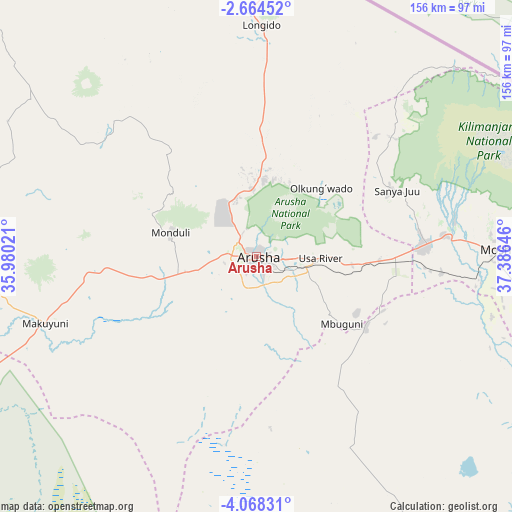
Arusha GPS coordinates[2]
3° 22' 0.012" South, 36° 40' 59.988" East
| Map corner | latitude | longitude |
|---|---|---|
| Upper-left | -2.66452°, | 35.98021° |
| Center: | -3.36667°, | 36.68333° |
| Lower-right: | -4.06831°, | 37.38646° |
| Map W x H: | 156.1×156.1 km | = 97×97mi |
| max Lat: | -1.14389° ⇑22.4% North |
| Arusha: | -3.36667° |
| min Lat: | ⇓77.6% South -11.36667° |
| min Long | Arusha | max Long |
| 29.62667° | 36.68333° | 40.33333° |
| W 61.5%⇐ | ⇒38.5% E |
Elevation
Elevation of Arusha is 1415 m = 4642 ft, and this is 472.2 m = 1549 ft above average elevation for this country.
| Max E: |
2377 m = 7799 ft | 20.6% |
| Arusha | 1415 m 4642 ft | |
| Avg. | 942.8 m = 3093 ft | |
Min E: |
0 m = 0 ft | 79.4% |
See also: Arusha elevation on elevation.city.
Geographical zone
Arusha is located in South Torrid zone (between Equator and Tropic of Capricorn). Distance of Equator is 374.3 km =232.6 mi to North.| Distance of | km | miles | from Arusha |
|---|---|---|---|
| Equator | 374.3 | 232.6 | to North |
| Tropic Capricorn | 2231.6 | 1386.7 | to South |
| Antarctic Circle | 7026.8 | 4366.2 | to South |
| South Pole | 9632.7 | 5985.5 | to South |


Nearby cities:
15 places around Arusha: (largest is in red/bold)
• Kingori
34.6 km =21.5 mi,  74°
74°
• Kiratu
112.9 km =70.2 mi,  271°
271°
• Kirya
107.8 km =67 mi,  124°
124°
• Lembeni
113.5 km =70.5 mi,  114°
114°
• Longido
70.5 km =43.8 mi,  1°
1°
• Mbuguni
37 km =23 mi,  126°
126°
• Merelani
39.3 km =24.4 mi, 123°
• Monduli
26.9 km =16.7 mi,  285°
285°
• Moshi
72.2 km =44.9 mi,  88°
88°
• Mto wa Mbu
92.5 km =57.5 mi, 271°
• Naberera
96.7 km =60.1 mi,  163°
163°
• Namanga
91.4 km =56.8 mi,  7°
7°
• Nkoaranga
13.5 km =8.4 mi, 74°
• Poli
13.5 km =8.4 mi, 74°
• Usa River
18.5 km =11.5 mi, 90°
Sources, notices
• [Note1] Compared only with cities in Tanzania existing in our database
• [Src1] Map data: © OpenStreetMap contributors (CC-BY-SA)
• [Src2] Other city data from geonames.org with taken over terms of usage.
• [Src3] Geographical zone / Annual Mean Temperature by Robert A. Rohde @ Wikipedia
