Mbuguni geodata
Mbuguni (Arusha) is a populated place; located in Tanzania in Africa/Dar_es_Salaam (GMT+3) time zone. With population of 16,442 people, there are 171 cities with bigger population in this country. Compared to other cities in Tanzania, 75.2% of cities are located further ↓South; 65% of cities are located further ←West and 60.5% of cities have higher elevation than Mbuguni. Note1


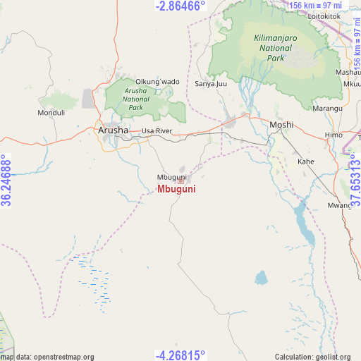
Mbuguni GPS coordinates[2]
3° 34' 0.012" South, 36° 57' 0" East
| Map corner | latitude | longitude |
|---|---|---|
| Upper-left | -2.86466°, | 36.24688° |
| Center: | -3.56667°, | 36.95° |
| Lower-right: | -4.26815°, | 37.65313° |
| Map W x H: | 156.1×156.1 km | = 97×97mi |
| max Lat: | -1.14389° ⇑24.8% North |
| Mbuguni: | -3.56667° |
| min Lat: | ⇓75.2% South -11.36667° |
| min Long | Mbuguni | max Long |
| 29.62667° | 36.95° | 40.33333° |
| W 65%⇐ | ⇒35% E |
Elevation
Elevation of Mbuguni is 921 m = 3022 ft, and this is 21.8 m = 72 ft below average elevation for this country.
| Max E: |
2377 m = 7799 ft | 60.5% |
| Avg. | 942.8 m = 3093 ft | |
| Mbuguni | 921 m = 3022 ft | |
Min E: |
0 m = 0 ft | 39.5% |
See also: Tanzania elevation on elevation.city.
Geographical zone
Mbuguni is located in South Torrid zone (between Equator and Tropic of Capricorn). Distance of Equator is 396.6 km =246.4 mi to North.| Distance of | km | miles | from Mbuguni |
|---|---|---|---|
| Equator | 396.6 | 246.4 | to North |
| Tropic Capricorn | 2209.3 | 1372.8 | to South |
| Antarctic Circle | 7004.6 | 4352.5 | to South |
| South Pole | 9610.5 | 5971.7 | to South |


Nearby cities:
15 places around Mbuguni: (largest is in red/bold)
• Arusha
37 km =23 mi,  306°
306°
• Kingori
31.7 km =19.7 mi,  6°
6°
• Kirya
70.8 km =44 mi,  123°
123°
• Kwakoa
87.9 km =54.6 mi,  104°
104°
• Lembeni
77.8 km =48.3 mi,  108°
108°
• Longido
96.8 km =60.1 mi,  343°
343°
• Merelani
3.3 km =2.1 mi,  80°
80°
• Monduli
62.9 km =39.1 mi,  298°
298°
• Moshi
48.9 km =30.4 mi,  60°
60°
• Naberera
70.4 km =43.7 mi,  181°
181°
• Namanga
114.4 km =71.1 mi,  350°
350°
• Nkoaranga
30.8 km =19.1 mi,  327°
327°
• Poli
30.8 km =19.1 mi, 327°
• Same
103.2 km =64.1 mi, 122°
• Usa River
24.9 km =15.5 mi, 333°
Sources, notices
• [Note1] Compared only with cities in Tanzania existing in our database
• [Src1] Map data: © OpenStreetMap contributors (CC-BY-SA)
• [Src2] Other city data from geonames.org with taken over terms of usage.
• [Src3] Geographical zone / Annual Mean Temperature by Robert A. Rohde @ Wikipedia
