Ilembula geodata
Ilembula (Njombe) is a populated place; located in Tanzania in Africa/Dar_es_Salaam (GMT+3) time zone. With population of 18,870 people, there are 139 cities with bigger population in this country. Compared to other cities in Tanzania, 80.4% of cities are located further ↑North; 58.4% of cities are located further →East and 80.4% of cities have lower elevation than Ilembula. Note1


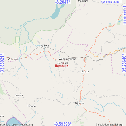
Ilembula GPS coordinates[2]
8° 54' 0" South, 34° 34' 59.988" East
| Map corner | latitude | longitude |
|---|---|---|
| Upper-left | -8.2047°, | 33.88021° |
| Center: | -8.9°, | 34.58333° |
| Lower-right: | -9.59398°, | 35.28646° |
| Map W x H: | 154.5×154.5 km | = 96×96mi |
| max Lat: | -1.14389° ⇑80.4% North |
| Ilembula: | -8.9° |
| min Lat: | ⇓19.6% South -11.36667° |
| min Long | Ilembula | max Long |
| 29.62667° | 34.58333° | 40.33333° |
| W 41.6%⇐ | ⇒58.4% E |
Elevation
Elevation of Ilembula is 1425 m = 4675 ft, and this is 482.2 m = 1582 ft above average elevation for this country.
| Max E: |
2377 m = 7799 ft | 19.6% |
| Ilembula | 1425 m 4675 ft | |
| Avg. | 942.8 m = 3093 ft | |
Min E: |
0 m = 0 ft | 80.4% |
See also: Tanzania elevation on elevation.city.
Geographical zone
Ilembula is located in South Torrid zone (between Equator and Tropic of Capricorn). Distance of Equator is 989.6 km =614.9 mi to North.| Distance of | km | miles | from Ilembula |
|---|---|---|---|
| Equator | 989.6 | 614.9 | to North |
| Tropic Capricorn | 1616.3 | 1004.3 | to South |
| Antarctic Circle | 6411.6 | 3984 | to South |
| South Pole | 9017.5 | 5603.2 | to South |


Nearby cities:
15 places around Ilembula: (largest is in red/bold)
• Chimala
61.6 km =38.3 mi,  274°
274°
• Dunda
94.5 km =58.7 mi,  337°
337°
• Igurusi
80.8 km =50.2 mi, 273°
• Ipinda
99.2 km =61.6 mi,  229°
229°
• Kandete
90.4 km =56.2 mi,  252°
252°
• Makumbako
28 km =17.4 mi,  78°
78°
• Makungu
79.1 km =49.2 mi, 76°
• Malangali
47.2 km =29.3 mi,  38°
38°
• Matamba
68.4 km =42.5 mi,  262°
262°
• Mlangali
98.5 km =61.2 mi,  184°
184°
• Mtwango
27.1 km =16.8 mi,  118°
118°
• Mwaya
100.3 km =62.3 mi,  223°
223°
• Njombe
54.1 km =33.6 mi,  157°
157°
• Rujewa
31.3 km =19.4 mi,  315°
315°
• Ulenje
98.9 km =61.5 mi, 267°
Sources, notices
• [Note1] Compared only with cities in Tanzania existing in our database
• [Src1] Map data: © OpenStreetMap contributors (CC-BY-SA)
• [Src2] Other city data from geonames.org with taken over terms of usage.
• [Src3] Geographical zone / Annual Mean Temperature by Robert A. Rohde @ Wikipedia
