Розгирче geodata
Розгирче (Ivano-Frankivsk) is a populated place; located in Ukraine in Europe/Kiev (GMT+3) time zone. With population of 566 people, there are 1610 cities with bigger population in this country. Compared to other cities in Ukraine, 68.9% of cities are located further ↓South; 94.5% of cities are located further →East and 94% of cities have lower elevation than Розгирче. Note1


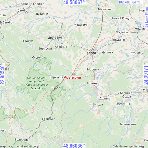
Розгирче GPS coordinates[2]
49° 7' 21.54" North, 23° 41' 18.888" East
| Map corner | latitude | longitude |
|---|---|---|
| Upper-left | 49.58067°, | 22.98546° |
| Center: | 49.12265°, | 23.68858° |
| Lower-right: | 48.66036°, | 24.39171° |
| Map W x H: | 102.3×102.3 km | = 63.6×63.6mi |
| max Lat: | 52.18903° ⇑31.1% North |
| Розгирче: | 49.12265° |
| min Lat: | ⇓68.9% South 44.39214° |
| min Long | Розгирч� | max Long |
| 22.20555° | 23.68858° | 40.13222° |
| W 5.5%⇐ | ⇒94.5% E |
Elevation
Elevation of Розгирче is 347 m = 1138 ft, and this is 191.2 m = 627 ft above average elevation for this country.
| Max E: |
886 m = 2907 ft | 6% |
| Розгирче | 347 m 1138 ft | |
| Avg. | 155.8 m = 511 ft | |
Min E: |
-3 m = -10 ft | 94% |
See also: Ukraine elevation on elevation.city.
Geographical zone
Розгирче is located in North temperate zone (between Tropic of Cancer and the Arctic Circle). Distance of this North polar circle is 1939.2 km =1205 mi to North.| Distance of | km | miles | from Розгирче |
|---|---|---|---|
| North Pole | 4545.1 | 2824.2 | to North |
| Arctic Circle | 1939.2 | 1205 | to North |
| Tropic Cancer | 2856 | 1774.6 | to South |
| Equator | 5461.9 | 3393.9 | to South |


Nearby cities:
15 places around Розгирче: (largest is in red/bold)
• Bolekhiv
14.3 km =8.9 mi,  116°
116°
• Boryslav
26.1 km =16.2 mi,  314°
314°
• Dolyna
28.7 km =17.8 mi,  125°
125°
• Drohobych
28.5 km =17.7 mi,  332°
332°
• Duliby
15.2 km =9.4 mi,  37°
37°
• Hrebeniv
23.1 km =14.4 mi,  220°
220°
• Morshyn
13.9 km =8.6 mi,  74°
74°
• Skhidnytsya
27.3 km =17 mi,  295°
295°
• Skole
15.9 km =9.9 mi,  233°
233°
• Stebnyk
21.1 km =13.1 mi, 334°
• Stryi
19.7 km =12.2 mi, 38°
• Truskavets’
21.8 km =13.5 mi,  322°
322°
• Tukhlia
28.2 km =17.5 mi,  213°
213°
• Ulychne
12.7 km =7.9 mi,  347°
347°
• Verkhnie Synevydne
7.4 km =4.6 mi,  252°
252°
Sources, notices
• [Note1] Compared only with cities in Ukraine existing in our database
• [Src1] Map data: © OpenStreetMap contributors (CC-BY-SA)
• [Src2] Other city data from geonames.org with taken over terms of usage.
• [Src3] Geographical zone / Annual Mean Temperature by Robert A. Rohde @ Wikipedia
