Bolekhiv geodata
Bolekhiv (Ivano-Frankivsk) is a populated place; located in Ukraine in Europe/Kiev (GMT+3) time zone. With population of 10,590 people, there are 343 cities with bigger population in this country. Compared to other cities in Ukraine, 67.7% of cities are located further ↓South; 93.7% of cities are located further →East and 95.3% of cities have lower elevation than Bolekhiv. Note1


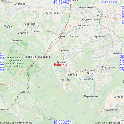
Bolekhiv GPS coordinates[2]
49° 3' 57.852" North, 23° 51' 51.66" East
| Map corner | latitude | longitude |
|---|---|---|
| Upper-left | 49.52462°, | 23.16123° |
| Center: | 49.06607°, | 23.86435° |
| Lower-right: | 48.60325°, | 24.56748° |
| Map W x H: | 102.4×102.4 km | = 63.6×63.6mi |
| max Lat: | 52.18903° ⇑32.3% North |
| Bolekhiv: | 49.06607° |
| min Lat: | ⇓67.7% South 44.39214° |
| min Long | Bolekhiv | max Long |
| 22.20555° | 23.86435° | 40.13222° |
| W 6.3%⇐ | ⇒93.7% E |
Elevation
Elevation of Bolekhiv is 365 m = 1198 ft, and this is 209.2 m = 686 ft above average elevation for this country.
| Max E: |
886 m = 2907 ft | 4.7% |
| Bolekhiv | 365 m 1198 ft | |
| Avg. | 155.8 m = 511 ft | |
Min E: |
-3 m = -10 ft | 95.3% |
See also: Ukraine elevation on elevation.city.
Geographical zone
Bolekhiv is located in North temperate zone (between Tropic of Cancer and the Arctic Circle). Distance of this North polar circle is 1945.5 km =1208.9 mi to North.| Distance of | km | miles | from Bolekhiv |
|---|---|---|---|
| North Pole | 4551.4 | 2828.1 | to North |
| Arctic Circle | 1945.5 | 1208.9 | to North |
| Tropic Cancer | 2849.7 | 1770.7 | to South |
| Equator | 5455.6 | 3390 | to South |


Nearby cities:
15 places around Bolekhiv: (largest is in red/bold)
• Broshniv-Osada
25.5 km =15.8 mi,  107°
107°
• Dolyna
14.8 km =9.2 mi,  134°
134°
• Duliby
18.7 km =11.6 mi,  349°
349°
• Hrebeniv
30.1 km =18.7 mi,  248°
248°
• Morshyn
10.1 km =6.3 mi,  3°
3°
• Rozhniativ
26.2 km =16.3 mi,  123°
123°
• Skole
25.8 km =16 mi,  262°
262°
• Spas
24.4 km =15.2 mi,  143°
143°
• Stebnyk
33.5 km =20.8 mi,  319°
319°
• Stryi
21.8 km =13.5 mi,  358°
358°
• Svarychiv
26.8 km =16.7 mi, 115°
• Tukhlia
33.3 km =20.7 mi,  239°
239°
• Ulychne
24.3 km =15.1 mi, 320°
• Verkhnie Synevydne
20.3 km =12.6 mi,  281°
281°
• Розгирче
14.3 km =8.9 mi,  296°
296°
Sources, notices
• [Note1] Compared only with cities in Ukraine existing in our database
• [Src1] Map data: © OpenStreetMap contributors (CC-BY-SA)
• [Src2] Other city data from geonames.org with taken over terms of usage.
• [Src3] Geographical zone / Annual Mean Temperature by Robert A. Rohde @ Wikipedia
