Zvenihorodka geodata
Zvenihorodka (Cherkasy) is a seat of a second-order administrative division; located in Ukraine in Europe/Kiev (GMT+3) time zone. With population of 19,161 people, there are 210 cities with bigger population in this country. Compared to other cities in Ukraine, 68% of cities are located further ↓South; 61.4% of cities are located further →East and 56.8% of cities have lower elevation than Zvenihorodka. Note1


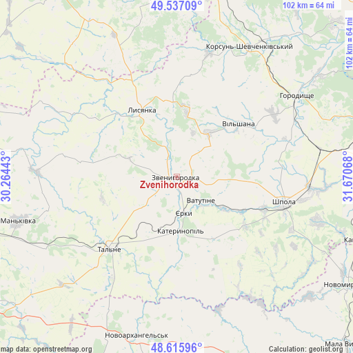
Zvenihorodka GPS coordinates[2]
49° 4' 43.176" North, 30° 58' 3.18" East
| Map corner | latitude | longitude |
|---|---|---|
| Upper-left | 49.53709°, | 30.26443° |
| Center: | 49.07866°, | 30.96755° |
| Lower-right: | 48.61596°, | 31.67068° |
| Map W x H: | 102.4×102.4 km | = 63.6×63.6mi |
| max Lat: | 52.18903° ⇑32% North |
| Zvenihorodka: | 49.07866° |
| min Lat: | ⇓68% South 44.39214° |
| min Long | Zvenihorodka | max Long |
| 22.20555° | 30.96755° | 40.13222° |
| W 38.6%⇐ | ⇒61.4% E |
Elevation
Elevation of Zvenihorodka is 158 m = 518 ft, and this is 2.2 m = 7 ft above average elevation for this country.
| Max E: |
886 m = 2907 ft | 43.2% |
| Zvenihorodka | 158 m 518 ft | |
| Avg. | 155.8 m = 511 ft | |
Min E: |
-3 m = -10 ft | 56.8% |
See also: Ukraine elevation on elevation.city.
Geographical zone
Zvenihorodka is located in North temperate zone (between Tropic of Cancer and the Arctic Circle). Distance of this North polar circle is 1944.1 km =1208 mi to North.| Distance of | km | miles | from Zvenihorodka |
|---|---|---|---|
| North Pole | 4550 | 2827.2 | to North |
| Arctic Circle | 1944.1 | 1208 | to North |
| Tropic Cancer | 2851.1 | 1771.6 | to South |
| Equator | 5457 | 3390.8 | to South |


Nearby cities:
15 places around Zvenihorodka: (largest is in red/bold)
• Buky
41.1 km =25.5 mi,  272°
272°
• Hlybochok
26.6 km =16.5 mi,  207°
207°
• Horodyshche
41.6 km =25.8 mi,  56°
56°
• Katerynopil
13.7 km =8.5 mi,  179°
179°
• Korsun-Shevchenkivskyi
43.3 km =26.9 mi,  29°
29°
• Lebedyn
42.8 km =26.6 mi,  107°
107°
• Lysianka
21.8 km =13.5 mi,  332°
332°
• Novoarkhanhel’s’k
48 km =29.8 mi,  193°
193°
• Shpola
32.1 km =19.9 mi,  104°
104°
• Stebliv
37.2 km =23.1 mi,  14°
14°
• Talne
29 km =18 mi,  223°
223°
• Tsvitkove
42.3 km =26.3 mi,  78°
78°
• Vatutine
9.9 km =6.2 mi,  135°
135°
• Yerky
9.9 km =6.2 mi,  171°
171°
• Yurkivka
11.6 km =7.2 mi,  130°
130°
Sources, notices
• [Note1] Compared only with cities in Ukraine existing in our database
• [Src1] Map data: © OpenStreetMap contributors (CC-BY-SA)
• [Src2] Other city data from geonames.org with taken over terms of usage.
• [Src3] Geographical zone / Annual Mean Temperature by Robert A. Rohde @ Wikipedia
