Tsvitkove geodata
Tsvitkove (Cherkasy) is a populated place; located in Ukraine in Europe/Kiev (GMT+3) time zone. With population of 1,265 people, there are 1276 cities with bigger population in this country. Compared to other cities in Ukraine, 69.1% of cities are located further ↓South; 59% of cities are located further →East and 61.9% of cities have lower elevation than Tsvitkove. Note1


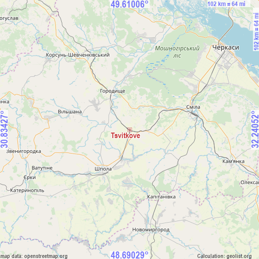
Tsvitkove GPS coordinates[2]
49° 9' 8.316" North, 31° 32' 14.604" East
| Map corner | latitude | longitude |
|---|---|---|
| Upper-left | 49.61006°, | 30.83427° |
| Center: | 49.15231°, | 31.53739° |
| Lower-right: | 48.69029°, | 32.24052° |
| Map W x H: | 102.3×102.3 km | = 63.6×63.6mi |
| max Lat: | 52.18903° ⇑30.9% North |
| Tsvitkove: | 49.15231° |
| min Lat: | ⇓69.1% South 44.39214° |
| min Long | Tsvitkove | max Long |
| 22.20555° | 31.53739° | 40.13222° |
| W 41%⇐ | ⇒59% E |
Elevation
Elevation of Tsvitkove is 175 m = 574 ft, and this is 19.2 m = 63 ft above average elevation for this country.
| Max E: |
886 m = 2907 ft | 38.1% |
| Tsvitkove | 175 m 574 ft | |
| Avg. | 155.8 m = 511 ft | |
Min E: |
-3 m = -10 ft | 61.9% |
See also: Ukraine elevation on elevation.city.
Geographical zone
Tsvitkove is located in North temperate zone (between Tropic of Cancer and the Arctic Circle). Distance of this North polar circle is 1935.9 km =1202.9 mi to North.| Distance of | km | miles | from Tsvitkove |
|---|---|---|---|
| North Pole | 4541.8 | 2822.1 | to North |
| Arctic Circle | 1935.9 | 1202.9 | to North |
| Tropic Cancer | 2859.3 | 1776.7 | to South |
| Equator | 5465.2 | 3395.9 | to South |


Nearby cities:
15 places around Tsvitkove: (largest is in red/bold)
• Horodyshche
16.2 km =10.1 mi,  335°
335°
• Kamianka
43.4 km =27 mi,  107°
107°
• Kapitanivka
29.2 km =18.1 mi,  153°
153°
• Korsun-Shevchenkivskyi
35.9 km =22.3 mi,  325°
325°
• Lebedyn
21.1 km =13.1 mi,  182°
182°
• Mliiv
20.6 km =12.8 mi,  355°
355°
• Novomyrhorod
42 km =26.1 mi,  169°
169°
• Ruska Poliana
40.5 km =25.2 mi,  43°
43°
• Shpola
19.2 km =11.9 mi,  212°
212°
• Smila
26.6 km =16.5 mi,  72°
72°
• Stebliv
42.3 km =26.3 mi,  311°
311°
• Vatutine
37.8 km =23.5 mi,  246°
246°
• Yerky
43.9 km =27.3 mi, 245°
• Yurkivka
36.3 km =22.6 mi,  244°
244°
• Zvenihorodka
42.3 km =26.3 mi,  258°
258°
Sources, notices
• [Note1] Compared only with cities in Ukraine existing in our database
• [Src1] Map data: © OpenStreetMap contributors (CC-BY-SA)
• [Src2] Other city data from geonames.org with taken over terms of usage.
• [Src3] Geographical zone / Annual Mean Temperature by Robert A. Rohde @ Wikipedia
