Lysianka geodata
Lysianka (Cherkasy) is a seat of a second-order administrative division; located in Ukraine in Europe/Kiev (GMT+3) time zone. With population of 7,954 people, there are 450 cities with bigger population in this country. Compared to other cities in Ukraine, 70.6% of cities are located further ↓South; 62.4% of cities are located further →East and 57.8% of cities have lower elevation than Lysianka. Note1


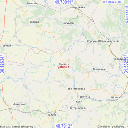
Lysianka GPS coordinates[2]
49° 15' 8.244" North, 30° 49' 46.056" East
| Map corner | latitude | longitude |
|---|---|---|
| Upper-left | 49.70911°, | 30.12634° |
| Center: | 49.25229°, | 30.82946° |
| Lower-right: | 48.7912°, | 31.53259° |
| Map W x H: | 102.1×102.1 km | = 63.4×63.4mi |
| max Lat: | 52.18903° ⇑29.4% North |
| Lysianka: | 49.25229° |
| min Lat: | ⇓70.6% South 44.39214° |
| min Long | Lysianka | max Long |
| 22.20555° | 30.82946° | 40.13222° |
| W 37.6%⇐ | ⇒62.4% E |
Elevation
Elevation of Lysianka is 160 m = 525 ft, and this is 4.2 m = 14 ft above average elevation for this country.
| Max E: |
886 m = 2907 ft | 42.2% |
| Lysianka | 160 m 525 ft | |
| Avg. | 155.8 m = 511 ft | |
Min E: |
-3 m = -10 ft | 57.8% |
See also: Ukraine elevation on elevation.city.
Geographical zone
Lysianka is located in North temperate zone (between Tropic of Cancer and the Arctic Circle). Distance of this North polar circle is 1924.8 km =1196 mi to North.| Distance of | km | miles | from Lysianka |
|---|---|---|---|
| North Pole | 4530.7 | 2815.2 | to North |
| Arctic Circle | 1924.8 | 1196 | to North |
| Tropic Cancer | 2870.4 | 1783.6 | to South |
| Equator | 5476.3 | 3402.8 | to South |


Nearby cities:
15 places around Lysianka: (largest is in red/bold)
• Bohuslav
33.2 km =20.6 mi,  5°
5°
• Buky
35.7 km =22.2 mi,  240°
240°
• Hlybochok
42.9 km =26.7 mi,  182°
182°
• Horodyshche
44.8 km =27.8 mi,  85°
85°
• Kalynove
31 km =19.3 mi,  297°
297°
• Karapyshi
43.5 km =27 mi,  356°
356°
• Katerynopil
34.5 km =21.4 mi,  162°
162°
• Korsun-Shevchenkivskyi
36.2 km =22.5 mi,  59°
59°
• Stebliv
25.6 km =15.9 mi,  49°
49°
• Talne
41.6 km =25.8 mi,  193°
193°
• Tarashcha
41.9 km =26 mi,  324°
324°
• Vatutine
31.3 km =19.4 mi,  147°
147°
• Yerky
31.3 km =19.4 mi, 158°
• Yurkivka
32.8 km =20.4 mi,  144°
144°
• Zvenihorodka
21.8 km =13.5 mi, 152°
Sources, notices
• [Note1] Compared only with cities in Ukraine existing in our database
• [Src1] Map data: © OpenStreetMap contributors (CC-BY-SA)
• [Src2] Other city data from geonames.org with taken over terms of usage.
• [Src3] Geographical zone / Annual Mean Temperature by Robert A. Rohde @ Wikipedia
