Korsun-Shevchenkivskyi geodata
Korsun-Shevchenkivskyi (Cherkasy) is a seat of a second-order administrative division; located in Ukraine in Europe/Kiev (GMT+3) time zone. With population of 19,000 people, there are 212 cities with bigger population in this country. Compared to other cities in Ukraine, 73.1% of cities are located further ↓South; 60.1% of cities are located further →East and 55.4% of cities have higher elevation than Korsun-Shevchenkivskyi. Note1


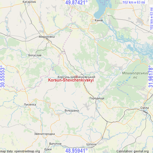
Korsun-Shevchenkivskyi GPS coordinates[2]
49° 25' 8.184" North, 31° 15' 31.14" East
| Map corner | latitude | longitude |
|---|---|---|
| Upper-left | 49.87421°, | 30.55553° |
| Center: | 49.41894°, | 31.25865° |
| Lower-right: | 48.95941°, | 31.96178° |
| Map W x H: | 101.7×101.7 km | = 63.2×63.2mi |
| max Lat: | 52.18903° ⇑26.9% North |
| Korsun-Shevchenkivskyi: | 49.41894° |
| min Lat: | ⇓73.1% South 44.39214° |
| min Long | Korsun-Shevchen | max Long |
| 22.20555° | 31.25865° | 40.13222° |
| W 39.9%⇐ | ⇒60.1% E |
Elevation
Elevation of Korsun-Shevchenkivskyi is 119 m = 390 ft, and this is 36.8 m = 121 ft below average elevation for this country.
| Max E: |
886 m = 2907 ft | 55.4% |
| Avg. | 155.8 m = 511 ft | |
| Korsun-Shevchenkivskyi | 119 m = 390 ft | |
Min E: |
-3 m = -10 ft | 44.6% |
See also: Ukraine elevation on elevation.city.
Geographical zone
Korsun-Shevchenkivskyi is located in North temperate zone (between Tropic of Cancer and the Arctic Circle). Distance of this North polar circle is 1906.3 km =1184.5 mi to North.| Distance of | km | miles | from Korsun-Shevchenkivskyi |
|---|---|---|---|
| North Pole | 4512.2 | 2803.8 | to North |
| Arctic Circle | 1906.3 | 1184.5 | to North |
| Tropic Cancer | 2889 | 1795.1 | to South |
| Equator | 5494.9 | 3414.4 | to South |


Nearby cities:
15 places around Korsun-Shevchenkivskyi: (largest is in red/bold)
• Bohuslav
31.3 km =19.4 mi,  297°
297°
• Horodyshche
20.1 km =12.5 mi,  137°
137°
• Kaniv
39.8 km =24.7 mi,  21°
21°
• Karapyshi
42 km =26.1 mi,  306°
306°
• Lysianka
36.2 km =22.5 mi,  239°
239°
• Mliiv
20.8 km =12.9 mi,  115°
115°
• Moshny
36.6 km =22.7 mi,  70°
70°
• Myronivka
33.4 km =20.8 mi,  323°
323°
• Ruska Poliana
47.8 km =29.7 mi,  90°
90°
• Shpola
46.9 km =29.1 mi,  167°
167°
• Stebliv
11.8 km =7.3 mi,  260°
260°
• Tsvitkove
35.9 km =22.3 mi,  145°
145°
• Vatutine
47.1 km =29.3 mi,  197°
197°
• Yurkivka
47 km =29.2 mi, 195°
• Zvenihorodka
43.3 km =26.9 mi,  209°
209°
Sources, notices
• [Note1] Compared only with cities in Ukraine existing in our database
• [Src1] Map data: © OpenStreetMap contributors (CC-BY-SA)
• [Src2] Other city data from geonames.org with taken over terms of usage.
• [Src3] Geographical zone / Annual Mean Temperature by Robert A. Rohde @ Wikipedia
