Stebliv geodata
Stebliv (Cherkasy) is a populated place; located in Ukraine in Europe/Kiev (GMT+3) time zone. With population of 3,859 people, there are 779 cities with bigger population in this country. Compared to other cities in Ukraine, 72.7% of cities are located further ↓South; 60.7% of cities are located further →East and 53.1% of cities have higher elevation than Stebliv. Note1


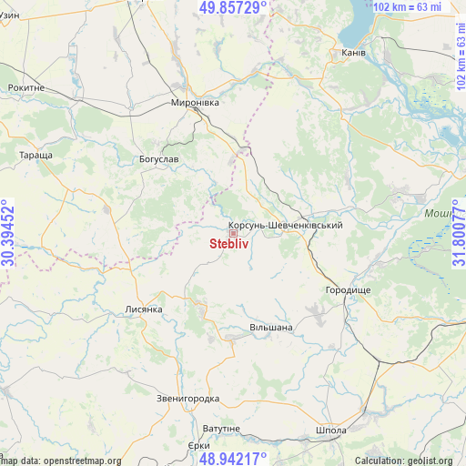
Stebliv GPS coordinates[2]
49° 24' 6.696" North, 31° 5' 51.504" East
| Map corner | latitude | longitude |
|---|---|---|
| Upper-left | 49.85729°, | 30.39452° |
| Center: | 49.40186°, | 31.09764° |
| Lower-right: | 48.94217°, | 31.80077° |
| Map W x H: | 101.8×101.7 km | = 63.3×63.2mi |
| max Lat: | 52.18903° ⇑27.3% North |
| Stebliv: | 49.40186° |
| min Lat: | ⇓72.7% South 44.39214° |
| min Long | Stebliv | max Long |
| 22.20555° | 31.09764° | 40.13222° |
| W 39.3%⇐ | ⇒60.7% E |
Elevation
Elevation of Stebliv is 125 m = 410 ft, and this is 30.8 m = 101 ft below average elevation for this country.
| Max E: |
886 m = 2907 ft | 53.1% |
| Avg. | 155.8 m = 511 ft | |
| Stebliv | 125 m = 410 ft | |
Min E: |
-3 m = -10 ft | 46.9% |
See also: Ukraine elevation on elevation.city.
Geographical zone
Stebliv is located in North temperate zone (between Tropic of Cancer and the Arctic Circle). Distance of this North polar circle is 1908.2 km =1185.7 mi to North.| Distance of | km | miles | from Stebliv |
|---|---|---|---|
| North Pole | 4514.1 | 2804.9 | to North |
| Arctic Circle | 1908.2 | 1185.7 | to North |
| Tropic Cancer | 2887.1 | 1794 | to South |
| Equator | 5493 | 3413.2 | to South |


Nearby cities:
15 places around Stebliv: (largest is in red/bold)
• Bohuslav
23 km =14.3 mi,  315°
315°
• Horodyshche
28.3 km =17.6 mi,  117°
117°
• Kalynove
46.8 km =29.1 mi,  267°
267°
• Kaniv
46.9 km =29.1 mi,  33°
33°
• Karapyshi
34.8 km =21.6 mi, 320°
• Korsun-Shevchenkivskyi
11.8 km =7.3 mi,  80°
80°
• Lysianka
25.6 km =15.9 mi,  229°
229°
• Mliiv
31.2 km =19.4 mi,  103°
103°
• Myronivka
29.9 km =18.6 mi,  343°
343°
• Tarashcha
47 km =29.2 mi,  291°
291°
• Tsvitkove
42.3 km =26.3 mi,  131°
131°
• Vatutine
43.1 km =26.8 mi,  183°
183°
• Yerky
46.4 km =28.8 mi,  189°
189°
• Yurkivka
43.5 km =27 mi, 180°
• Zvenihorodka
37.2 km =23.1 mi, 194°
Sources, notices
• [Note1] Compared only with cities in Ukraine existing in our database
• [Src1] Map data: © OpenStreetMap contributors (CC-BY-SA)
• [Src2] Other city data from geonames.org with taken over terms of usage.
• [Src3] Geographical zone / Annual Mean Temperature by Robert A. Rohde @ Wikipedia
