Buky geodata
Buky (Cherkasy) is a populated place; located in Ukraine in Europe/Kiev (GMT+3) time zone. With population of 2,230 people, there are 1072 cities with bigger population in this country. Compared to other cities in Ukraine, 68.4% of cities are located further ↓South; 65.2% of cities are located further →East and 74.7% of cities have lower elevation than Buky. Note1


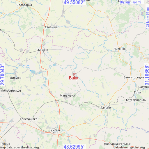
Buky GPS coordinates[2]
49° 5' 33.072" North, 30° 24' 12.78" East
| Map corner | latitude | longitude |
|---|---|---|
| Upper-left | 49.55082°, | 29.70043° |
| Center: | 49.09252°, | 30.40355° |
| Lower-right: | 48.62995°, | 31.10668° |
| Map W x H: | 102.4×102.4 km | = 63.6×63.6mi |
| max Lat: | 52.18903° ⇑31.6% North |
| Buky: | 49.09252° |
| min Lat: | ⇓68.4% South 44.39214° |
| min Long | Buky | max Long |
| 22.20555° | 30.40355° | 40.13222° |
| W 34.8%⇐ | ⇒65.2% E |
Elevation
Elevation of Buky is 225 m = 738 ft, and this is 69.2 m = 227 ft above average elevation for this country.
| Max E: |
886 m = 2907 ft | 25.3% |
| Buky | 225 m 738 ft | |
| Avg. | 155.8 m = 511 ft | |
Min E: |
-3 m = -10 ft | 74.7% |
See also: Ukraine elevation on elevation.city.
Geographical zone
Buky is located in North temperate zone (between Tropic of Cancer and the Arctic Circle). Distance of this North polar circle is 1942.6 km =1207.1 mi to North.| Distance of | km | miles | from Buky |
|---|---|---|---|
| North Pole | 4548.5 | 2826.3 | to North |
| Arctic Circle | 1942.6 | 1207.1 | to North |
| Tropic Cancer | 2852.7 | 1772.6 | to South |
| Equator | 5458.6 | 3391.8 | to South |


Nearby cities:
15 places around Buky: (largest is in red/bold)
• Babanka
42.7 km =26.5 mi,  175°
175°
• Hlybochok
38.2 km =23.7 mi,  131°
131°
• Kalynove
32.4 km =20.1 mi,  6°
6°
• Lysianka
35.7 km =22.2 mi,  60°
60°
• Mankivka
15.2 km =9.4 mi,  199°
199°
• Nove-Misto
43.7 km =27.2 mi,  253°
253°
• Roskoshnyy
34.8 km =21.6 mi,  332°
332°
• Stavyshche
36.6 km =22.7 mi,  335°
335°
• Talne
31.1 km =19.3 mi,  136°
136°
• Tanske
33.3 km =20.7 mi, 181°
• Tsibulev
40.5 km =25.2 mi,  267°
267°
• Uman
40.5 km =25.2 mi, 199°
• Verkhniachka
39.6 km =24.6 mi,  222°
222°
• Zhashkiv
27.3 km =17 mi,  308°
308°
• Zvenihorodka
41.1 km =25.5 mi,  92°
92°
Sources, notices
• [Note1] Compared only with cities in Ukraine existing in our database
• [Src1] Map data: © OpenStreetMap contributors (CC-BY-SA)
• [Src2] Other city data from geonames.org with taken over terms of usage.
• [Src3] Geographical zone / Annual Mean Temperature by Robert A. Rohde @ Wikipedia
