Novoarkhanhel’s’k geodata
Novoarkhanhel’s’k (Kirovohrad) is a seat of a second-order administrative division; located in Ukraine in Europe/Kiev (GMT+3) time zone. With population of 7,624 people, there are 472 cities with bigger population in this country. Compared to other cities in Ukraine, 59.2% of cities are located further ↓South; 62.6% of cities are located further →East and 50.1% of cities have higher elevation than Novoarkhanhel’s’k. Note1


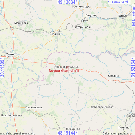
Novoarkhanhel’s’k GPS coordinates[2]
48° 39' 28.908" North, 30° 49' 5.556" East
| Map corner | latitude | longitude |
|---|---|---|
| Upper-left | 49.12034°, | 30.11509° |
| Center: | 48.65803°, | 30.81821° |
| Lower-right: | 48.19144°, | 31.52134° |
| Map W x H: | 103.3×103.3 km | = 64.2×64.2mi |
| max Lat: | 52.18903° ⇑40.8% North |
| Novoarkhanhel’s’k: | 48.65803° |
| min Lat: | ⇓59.2% South 44.39214° |
| min Long | Novoarkhanhel� | max Long |
| 22.20555° | 30.81821° | 40.13222° |
| W 37.4%⇐ | ⇒62.6% E |
Elevation
Elevation of Novoarkhanhel’s’k is 134 m = 440 ft, and this is 21.8 m = 72 ft below average elevation for this country.
| Max E: |
886 m = 2907 ft | 50.1% |
| Avg. | 155.8 m = 511 ft | |
| Novoarkhanhel’s’k | 134 m = 440 ft | |
Min E: |
-3 m = -10 ft | 49.9% |
See also: Ukraine elevation on elevation.city.
Geographical zone
Novoarkhanhel’s’k is located in North temperate zone (between Tropic of Cancer and the Arctic Circle). Distance of this North polar circle is 1990.9 km =1237.1 mi to North.| Distance of | km | miles | from Novoarkhanhel’s’k |
|---|---|---|---|
| North Pole | 4596.8 | 2856.3 | to North |
| Arctic Circle | 1990.9 | 1237.1 | to North |
| Tropic Cancer | 2804.3 | 1742.5 | to South |
| Equator | 5410.3 | 3361.8 | to South |


Nearby cities:
15 places around Novoarkhanhel’s’k: (largest is in red/bold)
• Babanka
27.8 km =17.3 mi,  281°
281°
• Dobrovelychkivka
40.2 km =25 mi,  138°
138°
• Hlybochok
23.3 km =14.5 mi,  356°
356°
• Holovanivs’k
40.2 km =25 mi,  220°
220°
• Katerynopil
34.8 km =21.6 mi,  18°
18°
• Lypnyazhka
30.2 km =18.8 mi, 141°
• Perehonivka
25.9 km =16.1 mi,  238°
238°
• Talne
27.2 km =16.9 mi,  340°
340°
• Tanske
34.7 km =21.6 mi,  295°
295°
• Tyshkivka
20.1 km =12.5 mi,  153°
153°
• Uman
44.9 km =27.9 mi, 282°
• Vatutine
43.5 km =27 mi, 24°
• Vil’shanka
47.1 km =29.3 mi,  174°
174°
• Yerky
39 km =24.2 mi, 18°
• Yurkivka
43.9 km =27.3 mi,  26°
26°
Sources, notices
• [Note1] Compared only with cities in Ukraine existing in our database
• [Src1] Map data: © OpenStreetMap contributors (CC-BY-SA)
• [Src2] Other city data from geonames.org with taken over terms of usage.
• [Src3] Geographical zone / Annual Mean Temperature by Robert A. Rohde @ Wikipedia
