Zolochiv geodata
Zolochiv (Lviv) is a seat of a second-order administrative division; located in Ukraine in Europe/Kiev (GMT+3) time zone. With population of 22,608 people, there are 181 cities with bigger population in this country. Compared to other cities in Ukraine, 79.6% of cities are located further ↓South; 86.7% of cities are located further →East and 85.2% of cities have lower elevation than Zolochiv. Note1


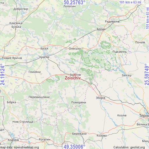
Zolochiv GPS coordinates[2]
49° 48' 21.492" North, 24° 53' 39.696" East
| Map corner | latitude | longitude |
|---|---|---|
| Upper-left | 50.25763°, | 24.19124° |
| Center: | 49.80597°, | 24.89436° |
| Lower-right: | 49.35006°, | 25.59749° |
| Map W x H: | 100.9×100.9 km | = 62.7×62.7mi |
| max Lat: | 52.18903° ⇑20.4% North |
| Zolochiv: | 49.80597° |
| min Lat: | ⇓79.6% South 44.39214° |
| min Long | Zolochiv | max Long |
| 22.20555° | 24.89436° | 40.13222° |
| W 13.3%⇐ | ⇒86.7% E |
Elevation
Elevation of Zolochiv is 276 m = 906 ft, and this is 120.2 m = 394 ft above average elevation for this country.
| Max E: |
886 m = 2907 ft | 14.8% |
| Zolochiv | 276 m 906 ft | |
| Avg. | 155.8 m = 511 ft | |
Min E: |
-3 m = -10 ft | 85.2% |
See also: Ukraine elevation on elevation.city.
Geographical zone
Zolochiv is located in North temperate zone (between Tropic of Cancer and the Arctic Circle). Distance of this North polar circle is 1863.3 km =1157.8 mi to North.| Distance of | km | miles | from Zolochiv |
|---|---|---|---|
| North Pole | 4469.2 | 2777 | to North |
| Arctic Circle | 1863.3 | 1157.8 | to North |
| Tropic Cancer | 2932 | 1821.9 | to South |
| Equator | 5537.9 | 3441.1 | to South |


Nearby cities:
15 places around Zolochiv: (largest is in red/bold)
• Brody
36.3 km =22.6 mi,  30°
30°
• Bus’k
26.9 km =16.7 mi,  311°
311°
• Dunayiv
21.6 km =13.4 mi,  193°
193°
• Krasne
23.5 km =14.6 mi,  300°
300°
• Nadrichne
30.7 km =19.1 mi,  171°
171°
• Olesko
17.4 km =10.8 mi,  359°
359°
• Ozerna
36.9 km =22.9 mi,  122°
122°
• Peremyshlyany
28.8 km =17.9 mi,  237°
237°
• Pidhirtsi
16.7 km =10.4 mi,  21°
21°
• Pidkamin’
34 km =21.1 mi,  62°
62°
• Pomoriany
18.5 km =11.5 mi, 171°
• Svirzh
37.1 km =23.1 mi, 241°
• Vyshnivchyk
15.8 km =9.8 mi,  222°
222°
• Zaliztsi
34.4 km =21.4 mi,  92°
92°
• Zboriv
23.7 km =14.7 mi,  131°
131°
In other languages:
- In France: Zolotchiv
- In German: Solotschiw
- In Italian: Zoločiv
- In Russian: Золочев
- In Chinese: 佐洛乔夫
Sources, notices
• [Note1] Compared only with cities in Ukraine existing in our database
• [Src1] Map data: © OpenStreetMap contributors (CC-BY-SA)
• [Src2] Other city data from geonames.org with taken over terms of usage.
• [Src3] Geographical zone / Annual Mean Temperature by Robert A. Rohde @ Wikipedia
