Yagel’nitsa Stara geodata
Yagel’nitsa Stara (Ternopil) is a populated place; located in Ukraine in Europe/Kiev (GMT+3) time zone. With population of 616 people, there are 1574 cities with bigger population in this country. Compared to other cities in Ukraine, 65.8% of cities are located further ↓South; 82.7% of cities are located further →East and 90.5% of cities have lower elevation than Yagel’nitsa Stara. Note1


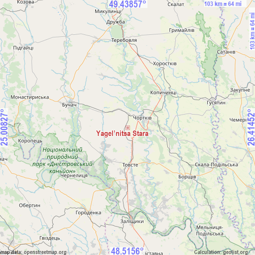
Yagel’nitsa Stara GPS coordinates[2]
48° 58' 45.192" North, 25° 42' 41.004" East
| Map corner | latitude | longitude |
|---|---|---|
| Upper-left | 49.43857°, | 25.00827° |
| Center: | 48.97922°, | 25.71139° |
| Lower-right: | 48.5156°, | 26.41452° |
| Map W x H: | 102.6×102.6 km | = 63.8×63.8mi |
| max Lat: | 52.18903° ⇑34.2% North |
| Yagel’nitsa Stara: | 48.97922° |
| min Lat: | ⇓65.8% South 44.39214° |
| min Long | Yagel’nitsa S | max Long |
| 22.20555° | 25.71139° | 40.13222° |
| W 17.3%⇐ | ⇒82.7% E |
Elevation
Elevation of Yagel’nitsa Stara is 310 m = 1017 ft, and this is 154.2 m = 506 ft above average elevation for this country.
| Max E: |
886 m = 2907 ft | 9.5% |
| Yagel’nitsa Stara | 310 m 1017 ft | |
| Avg. | 155.8 m = 511 ft | |
Min E: |
-3 m = -10 ft | 90.5% |
See also: Ukraine elevation on elevation.city.
Geographical zone
Yagel’nitsa Stara is located in North temperate zone (between Tropic of Cancer and the Arctic Circle). Distance of this North polar circle is 1955.2 km =1214.9 mi to North.| Distance of | km | miles | from Yagel’nitsa Stara |
|---|---|---|---|
| North Pole | 4561.1 | 2834.1 | to North |
| Arctic Circle | 1955.2 | 1214.9 | to North |
| Tropic Cancer | 2840.1 | 1764.8 | to South |
| Equator | 5446 | 3384 | to South |


Nearby cities:
15 places around Yagel’nitsa Stara: (largest is in red/bold)
• Belaya
7 km =4.3 mi,  37°
37°
• Borshchiv
31.2 km =19.4 mi,  128°
128°
• Buchach
25.3 km =15.7 mi,  291°
291°
• Chernelytsya
28 km =17.4 mi,  228°
228°
• Chortkiv
7.6 km =4.7 mi,  56°
56°
• Druzhba
20.3 km =12.6 mi, 290°
• Husiatyn
36.1 km =22.4 mi,  73°
73°
• Khorostkiv
30 km =18.6 mi,  30°
30°
• Kopychyntsi
20.1 km =12.5 mi,  46°
46°
• Nyrkiv
20 km =12.4 mi,  204°
204°
• Terebovlya
35.9 km =22.3 mi,  359°
359°
• Tovste
14.8 km =9.2 mi,  175°
175°
• Yablonovka
19.8 km =12.3 mi,  265°
265°
• Yahil’nytsya
4.7 km =2.9 mi,  149°
149°
• Zolotyy Potik
28.3 km =17.6 mi,  254°
254°
Sources, notices
• [Note1] Compared only with cities in Ukraine existing in our database
• [Src1] Map data: © OpenStreetMap contributors (CC-BY-SA)
• [Src2] Other city data from geonames.org with taken over terms of usage.
• [Src3] Geographical zone / Annual Mean Temperature by Robert A. Rohde @ Wikipedia
