Terebovlya geodata
Terebovlya (Ternopil) is a seat of a second-order administrative division; located in Ukraine in Europe/Kiev (GMT+3) time zone. With population of 13,153 people, there are 282 cities with bigger population in this country. Compared to other cities in Ukraine, 71.2% of cities are located further ↓South; 82.8% of cities are located further →East and 94.3% of cities have lower elevation than Terebovlya. Note1


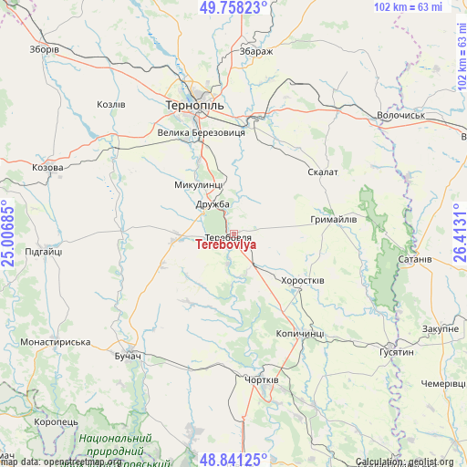
Terebovlya GPS coordinates[2]
49° 18' 6.732" North, 25° 42' 35.892" East
| Map corner | latitude | longitude |
|---|---|---|
| Upper-left | 49.75823°, | 25.00685° |
| Center: | 49.30187°, | 25.70997° |
| Lower-right: | 48.84125°, | 26.4131° |
| Map W x H: | 102×102 km | = 63.4×63.4mi |
| max Lat: | 52.18903° ⇑28.8% North |
| Terebovlya: | 49.30187° |
| min Lat: | ⇓71.2% South 44.39214° |
| min Long | Terebovlya | max Long |
| 22.20555° | 25.70997° | 40.13222° |
| W 17.2%⇐ | ⇒82.8% E |
Elevation
Elevation of Terebovlya is 350 m = 1148 ft, and this is 194.2 m = 637 ft above average elevation for this country.
| Max E: |
886 m = 2907 ft | 5.7% |
| Terebovlya | 350 m 1148 ft | |
| Avg. | 155.8 m = 511 ft | |
Min E: |
-3 m = -10 ft | 94.3% |
See also: Ukraine elevation on elevation.city.
Geographical zone
Terebovlya is located in North temperate zone (between Tropic of Cancer and the Arctic Circle). Distance of this North polar circle is 1919.3 km =1192.6 mi to North.| Distance of | km | miles | from Terebovlya |
|---|---|---|---|
| North Pole | 4525.2 | 2811.8 | to North |
| Arctic Circle | 1919.3 | 1192.6 | to North |
| Tropic Cancer | 2875.9 | 1787 | to South |
| Equator | 5481.9 | 3406.3 | to South |


Nearby cities:
15 places around Terebovlya: (largest is in red/bold)
• Belaya
30.7 km =19.1 mi,  171°
171°
• Buchach
35.4 km =22 mi,  221°
221°
• Chortkiv
32.3 km =20.1 mi, 168°
• Druzhba
34.5 km =21.4 mi,  213°
213°
• Hrymayliv
22.1 km =13.7 mi,  81°
81°
• Khorostkiv
18.4 km =11.4 mi,  123°
123°
• Kopychyntsi
26.3 km =16.3 mi,  146°
146°
• Mikulintsy
12.9 km =8 mi,  324°
324°
• Petrikov
27.2 km =16.9 mi,  339°
339°
• Skalat
23.9 km =14.9 mi,  54°
54°
• Ternopil
29.3 km =18.2 mi, 342°
• Velikiye Borki
24.9 km =15.5 mi,  7°
7°
• Yagel’nitsa Stara
35.9 km =22.3 mi,  179°
179°
• Yahil’nytsya
40 km =24.9 mi, 176°
• Zbarazh
40.5 km =25.2 mi, 6°
Sources, notices
• [Note1] Compared only with cities in Ukraine existing in our database
• [Src1] Map data: © OpenStreetMap contributors (CC-BY-SA)
• [Src2] Other city data from geonames.org with taken over terms of usage.
• [Src3] Geographical zone / Annual Mean Temperature by Robert A. Rohde @ Wikipedia
