Tovste geodata
Tovste (Ternopil) is a populated place; located in Ukraine in Europe/Kiev (GMT+3) time zone. With population of 3,382 people, there are 850 cities with bigger population in this country. Compared to other cities in Ukraine, 62.9% of cities are located further ↓South; 82.5% of cities are located further →East and 86.3% of cities have lower elevation than Tovste. Note1


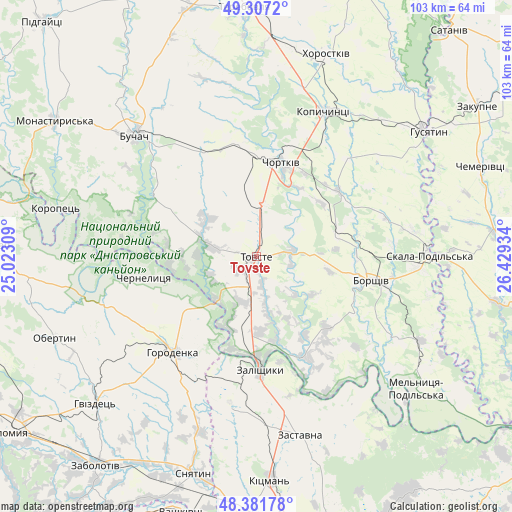
Tovste GPS coordinates[2]
48° 50' 47.868" North, 25° 43' 34.356" East
| Map corner | latitude | longitude |
|---|---|---|
| Upper-left | 49.3072°, | 25.02309° |
| Center: | 48.84663°, | 25.72621° |
| Lower-right: | 48.38178°, | 26.42934° |
| Map W x H: | 102.9×102.9 km | = 63.9×63.9mi |
| max Lat: | 52.18903° ⇑37.1% North |
| Tovste: | 48.84663° |
| min Lat: | ⇓62.9% South 44.39214° |
| min Long | Tovste | max Long |
| 22.20555° | 25.72621° | 40.13222° |
| W 17.5%⇐ | ⇒82.5% E |
Elevation
Elevation of Tovste is 282 m = 925 ft, and this is 126.2 m = 414 ft above average elevation for this country.
| Max E: |
886 m = 2907 ft | 13.7% |
| Tovste | 282 m 925 ft | |
| Avg. | 155.8 m = 511 ft | |
Min E: |
-3 m = -10 ft | 86.3% |
See also: Ukraine elevation on elevation.city.
Geographical zone
Tovste is located in North temperate zone (between Tropic of Cancer and the Arctic Circle). Distance of this North polar circle is 1969.9 km =1224 mi to North.| Distance of | km | miles | from Tovste |
|---|---|---|---|
| North Pole | 4575.8 | 2843.3 | to North |
| Arctic Circle | 1969.9 | 1224 | to North |
| Tropic Cancer | 2825.3 | 1755.6 | to South |
| Equator | 5431.2 | 3374.8 | to South |


Nearby cities:
15 places around Tovste: (largest is in red/bold)
• Belaya
20.5 km =12.7 mi,  9°
9°
• Borshchiv
23.7 km =14.7 mi,  101°
101°
• Chernelytsya
22.4 km =13.9 mi,  260°
260°
• Chernyatyn
29.1 km =18.1 mi,  224°
224°
• Chortkiv
19.7 km =12.2 mi,  15°
15°
• Druzhba
29.7 km =18.5 mi,  317°
317°
• Horodenka
25.4 km =15.8 mi, 220°
• Kadubivtsi
29.4 km =18.3 mi,  173°
173°
• Kostryzhivka
21.4 km =13.3 mi,  182°
182°
• Nyrkiv
9.9 km =6.2 mi,  249°
249°
• Yablonovka
24.6 km =15.3 mi,  302°
302°
• Yagel’nitsa Stara
14.8 km =9.2 mi,  355°
355°
• Yahil’nytsya
10.7 km =6.6 mi, 6°
• Zalishchyky
22.6 km =14 mi, 177°
• Zolotyy Potik
29.1 km =18.1 mi,  283°
283°
Sources, notices
• [Note1] Compared only with cities in Ukraine existing in our database
• [Src1] Map data: © OpenStreetMap contributors (CC-BY-SA)
• [Src2] Other city data from geonames.org with taken over terms of usage.
• [Src3] Geographical zone / Annual Mean Temperature by Robert A. Rohde @ Wikipedia
